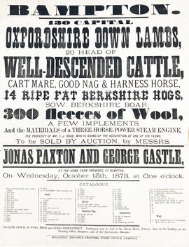
Old Poster dated October 15th 1873. Advertising the sale of Oxfordshire Down Lamb, Cattle, Horses, Hogs and Wool, and Steam Engines. To be sold at Auction b Jonas Paxton and George Castle. At Home Farm Premises, Bampton
In October 2012 the Bampton Environmental Watch Group had a wonderful talk given by John Leighfield on the history of maps and in particular maps of Oxfordshire and Bampton. It was very interesting to note that the first maps of Bampton showed the rivers and streams but no roads, showing the importance of waterways. It really is worth looking at the maps of Bampton carefully, you'll see just how old some buildings are, where the mill was in Bampton and Kerwoods Yard which was one area for the very poor with dwellings that had no land with them, they afforded the occupier a roof as opposed to 'the park bench' but no land on which to produce any food. It's referred to in early census forms and people come to Bampton asking where it is - it's on page 15 of this pdf
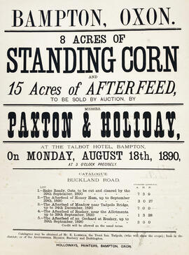
Poster dated August 18th 1890 advertising the auction of 8 acres of standing corn and 15 Acres of afterfield on Buckland Road. Auctioneers Paxton and Holiday to be held at The Talbot Hotel.
These three maps are all labelled as 2nd edition 1899. They cover the area Central Bampton, north & south, east nearly to Aston, Black Bourton south to Cowleaze Corner, east to Elephant & Castle in Bridge Street and Mt Owen Rd, west to road going up to Lew now called Station Road. They not only show the buildings but someone has written on in pencil when certain plots were sold and to whom. Interesting to see the clear fish-farming area with the Deanery then called Deanery Farm, Cobb House simply called Vicarage, Churchgate House called Trinity Vicarage. The third vicarage is today called Kilmore House and is almost opposite the East window of St. Mary's. What today is called Bridge Street was then called Mill Street and the mill was just to the left of path to Sandford Field from Bridge St. The legend is the mill wheel was buried in the plot to the left of the brook walking to the field from Bridge St and the tree there today was planted at its centre.
First of three Second Edition 1899 Ordnance Survey Maps showing Central Bampton, north & south, east nearly to Aston, Someone has annotated the map with pencil showing who owns various fields, and when bought and the cost. Names of people owning fields
Mr. Wilkins JG Andrews Trustees FF Southby Stevens of Calais Farm WW Shepherd Mr Rose Mr Carter Sold 18th May 1950 L H Saunders for £400 Sold 18th May 1950 Mr Read for £700 L Dafter Sold 18th May 1950 to F A Gerring for £2275
Places shown on Map in 1899 as follows: Beam Cottage Bridge Street Calais Farm Cheapside Church Street Fishers Bridge Manor Cottage Manor House New Inn Lane Primrose Cottages Swan Inn The Grange
Third of 3 Second Edition 1899 Ordnance Survey Maps Showing Mount Owen Road towards Lew. There are some pencil notes and some fields are coloured yellow. The following places are shown Lew Lodge Coalpit Farm Mount Owen Farm Ditcham Wood Rushey Butts
Second of three Second Edition 1899 Ordnance Survey Maps showing Black Bourton, Cowleaze Corner to Central Bampton and shows the following places Manor House Mill Bridge Millgreen Terrace New Inn Lane Plantation Sandford Villa Swan Inn The Grange Trinity Vicarage Weald Manor House