Showing 26 results
Archival description
Bampton maps of 1921

1974 OS map of Bampton and Aston

Maps of East Half of Bampton 1921

1797 Map showing Bampton Hundred

Ordnance Survey PlanSP3002-3102 Weald, Hayway Lane, Weald St, Clanfield Rd. 1971

Ordnance Survey Map dated 1922 Grafton to Chimney including villages
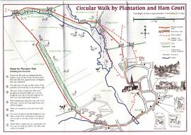
Circular Walk Map - Plantation and Ham Court

Second Edition 1899. Ordnance Survey Map Black Bourton, Cowleaze Corner east to Central Bampton

Map of 1797. Westwell east to Curbridge, Kemscott east to Coat Common plus St Giles Oxford

1913 map of Weald, west to Marsh Lane on east edge of Clanfield
Results 11 to 20 of 26
- « Previous
- 1
- 2
- 3
- Next »