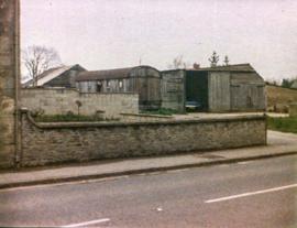
Castle View farm and house c1971
- BCA - 2021.3141
- Item
- c1971
Castle View farm and house c1971
Nik Stanbridge
206 results with digital objects Show results with digital objects
Castle View farm and house c1971
Castle View farm and house c1971
Nik Stanbridge

Ordnance Survey Plan SP3002-3102 1971. Cowleaze Corner Weald to Aston Road
Ordnance Survey Plan SP3002-3102 dated 1971. Cowleaze Corner, Weald to Aston, north to Horse Shoe
and showing the following places and buildings
Ashtree
Aulnoy
Backhouse Farm
Bournemead
Brook Farm
Brook House
Buckland Road
Caravan Park
Cheyne Lane
Clanfield Road
College Farm House
Corner Farm
Cowleaze Corner
Cricket Field
Dunlaoghaire
Fisher's Bridge
Gate Cottage
Glebe Cottage
Glebe Farm
Ham Court
Ham Court Cottages
Highmoor House
Knapps Farm
Lime Tree Cottages
Mill Bridge
Mill Green
Orchard Cottage
Primrose Cottages
Rose Cottage
Shill Brook
Shrangi-la
Spring Cottages
St Frideswide
Stable Cottage
Sunny view
Sunnyside
Thatch Cottage
The Bungalow
The Lodge
The Old Farmhouse
Weald Farm
Weald Farm Cottages
Weald Manor
Weald Manor Cottage
Weald Manor Farm
Janet Westman

These four maps were all produce in 1971 and cover
Ordinance Survey Plan SP3002-3102 Weald, Hayway Lane, Weald St, Clanfield Road
Ordinance Survey Plan SP3003-3103. Bridge St east to end of houses, north to new school, Colvile Close
Ordinance Survey Plan SP3203-3303. 1971 Mt Owen Rd east inc. Gogg Lane, Aston Rod to Aston
Ordinance Survey Plan SP3002-3102 1971. Cowleaze Corner, Weald to Aston, north to Horse Shoe PH
Fields, property and farms are all clearly marked.
Bampton Community Archive
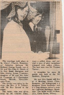
These newspaper cuttings, all from local papers are from 1972. Topics covered include:
Bampton Community Archive

1974 OS map of Bampton and Aston
This Ordinance Survey map was produced in 1974 and covers the area from Hobbs buildings/Deanery Farm in the north, due east to Coal Pit Farm, south to Bampton centre, on south to Weald, east to Aston and south to the Radcot Cut and Great Brook and the Thames.
Bampton Community Archive
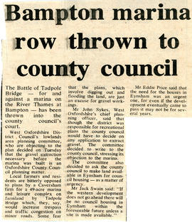
Bampton Marina to be decided upon by County Council
A Caversham firm want to make a 49 acre marina at Tadpole Bridge on the Thames. WODC lowlands area planning committee are objecting tot he plan because gravel extraction will have to take place first a marina could be built. The decision has been put into the hands of the County Council.
Now 2021 and no marina has been built or gravel extracted.
Nik Stanbridge
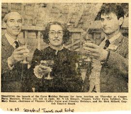
Celebrating the formation of the Farm Holiday Bureau
Celebrating the launch of the nationwide Farm Holiday Bureau are Mr Nick Hooper, Mrs Mary Rouse from Lew and Mr Dick Millard of the English Tourist Board. Nick and Mary were members of the local group, the Thames Valley Farm and Country Holiday group and were part of a small group of people from across the UK to set up the national organisation with included members in England, Wales, Scotland and N Ireland. Several years down the line the name was changed from Farm Holiday Bureau to Farm Stay UK. The launch was held at Cogges Farm in Cogges next to Witney.
Bampton Community Archive

Nick Hooper, Mary Rouse & Dick Millard
Nick Hooper, Mary Rouse & Dick Millard
Nik Stanbridge
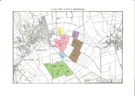
Document detailing the sale of Calais Farm in 1984
A PDF document of 9 pages detailing the sale of Calais Farm in 1984 by Moore, Allen and Innocent for Mr Bryan Stevens. About 185 acres freehold with vacant possession for sale by private treaty as a whole or in six lots
Nik Stanbridge
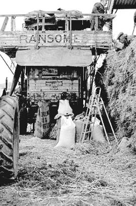
Colin Rouse experiments with old-style thrashing at Hobbs buildings
Colin Rouse experiments with old-style thrashing at Hobbs buildings with a Ransomes thresher, 1985
Nik Stanbridge