- BCA - 2019.1954
- Item
- 1890
'Father and Dart' in 1890. Picture donated by RHC Davies. The name of 'Father' is not known
Bampton Community Archive
455 results with digital objects Show results with digital objects
'Father and Dart' in 1890. Picture donated by RHC Davies. The name of 'Father' is not known
Bampton Community Archive
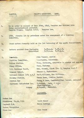
One page from Kelly's Directory 1985
Bampton Proper, Bampton Aston and Bampton Lew
lists people responsible for Cemetry.
Lighting
Police Station
Drainage
Grammar School
National School
Station Bar
Carriers
Janet Westman

Second Edition 1899. Ordnance Survey Map Central Bampton east towards Aston
First of three Second Edition 1899 Ordnance Survey Maps showing Central Bampton, north & south, east nearly to Aston, Someone has annotated the map with pencil showing who owns various fields, and when bought and the cost.
Names of people owning fields
Mr. Wilkins
JG Andrews Trustees
FF Southby
Stevens of Calais Farm
WW Shepherd
Mr Rose
Mr Carter
Sold 18th May 1950 L H Saunders for £400
Sold 18th May 1950 Mr Read for £700
L Dafter
Sold 18th May 1950 to F A Gerring for £2275
Places shown on Map in 1899 as follows:
Beam Cottage
Bridge Street
Calais Farm
Cheapside
Church Street
Fishers Bridge
Manor Cottage
Manor House
New Inn Lane
Primrose Cottages
Swan Inn
The Grange
Janet Westman

Second Edition 1899 Ordnance Survey Map Mt Owen Rd, west towards Lew
Third of 3 Second Edition 1899 Ordnance Survey Maps Showing Mount Owen Road towards Lew. There are some pencil notes and some fields are coloured yellow.
The following places are shown
Lew Lodge
Coalpit Farm
Mount Owen Farm
Ditcham Wood
Rushey Butts
Janet Westman

Second Edition 1899. Ordnance Survey Map Black Bourton, Cowleaze Corner east to Central Bampton
Second of three Second Edition 1899 Ordnance Survey Maps showing Black Bourton, Cowleaze Corner to Central Bampton
and shows the following places
Manor House
Mill Bridge
Millgreen Terrace
New Inn Lane
Plantation
Sandford Villa
Swan Inn
The Grange
Trinity Vicarage
Weald Manor House
Janet Westman
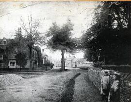
Old b/w photo of Broad Street, showing The Elms on the left, and Deanery Farm on the right, two little girls leaning against the wall on right hand side. No date.
Janet Westman
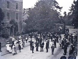
'Go Thou and Do Likewise' is on the top of the banner of the Friendly Society. On Hospital Sunday the members walked from their headquarters in one of the inns to St Mary's for a service and in this picture, they are seen leaving after the annual service. Before the days of the National Health Service, those who could, paid into 'the club' ie the Friendly Society and if they were ill and could not work, sufficient money was provided for the family to buy food. It was literally a life saver for them. The National Health Service came into being July 5th 1948.
1a Foresters A photograph of the Foresters with their banner outside Oathurst, now called Rosebank Nursing Home. Bampton’s Brass band is with them. People paid into clubs like the Foresters then, if they were unable to work, the club kept them from starving. This was before the welfare state came into being and so these friendly societies were very important.
Janet Westman

Plan of the Lew Estate, Oxfordshire divided into coloured sections/Lots for sale by auction by Messrs Knight, Frank and Rutley .
Janet Westman

Maps of East Half of Bampton 1921
3 Large ordnance Survey Maps used by Hadgood and Mammatt Auctioneers and Estate Agents from Witney. Published in 1921 price £5/- and £6/8d. Points of interest are Highmoor Brook, Plantation, Ham Court, Deanery Farm, Churchgate, Vicarage, Manor House, and Weald Manor House, old gravel pit and Beam Cottage, Calais Farm, Primrose Cottages, Fisher's Bridge
Janet Westman

Ordnance Survey Map dated 1922 Grafton to Chimney including villages
Ordnance Survey Map Dated 1922. showing villages from Grafton Clanfield, Alvescot, Bampton south to Thames, Aston, Chimney
There are pencil notes on the map difficult to read'
The places printed on map are as follows
Bampton
Baptist Chapel
Beam Cottage
Bridge Street
Broad Street
Broad Street
Calais Farm
Castle remains
Cheapside
Church Lane
Churchgate House
Coalpit Farm
Deanery Farm
Elephant and Castle
Fishers Bridge
Gas Works
Ham Court
Highmoor Brook
Lady Well
Manor Cottage
Manor House
Mill Barn
Mill Bridge
Mount Owen Farm
New Inn Lane
Old Gravel Pit
Plantation
Primrose Cottages
Sandford Villa
Swan Inn
The Grange
Vicarage
Water Tower
Weald Manor House
Windmill House
Wrights hill
Lower Haddon Farm
Ven Bridge
Elmwood House
Alvescot
Alvescot House
Alvescot Lodge
Alvescot Mill
Alvescot Station
Bates Land Farm
Buxhill Farm
Manor Farm Alvescot
Milestone Road
Old Chapel Pit
Plough Inn
Rectory Farm
Red Lion PH
Royal George PH
Shield Farm
Smithy
St Peters Church
The Rectory
Vine Cottage
Clanfield
Little Clanfield
Grafton Green Farm
Little Clanfield Mill
Manor Farm
Radcot
Radcot New Buildings
Langley Lane
Langford Brook
Ashton Pill Bridge
Swan Inn
Cradle Bridge (Foot)
Radcot Bridge
River Thames
Entrenchment The Garrison
Towing Path
Radcot Lock
Sharney Brook
Burroway Brook
Burroway Bridge
Sharney Bridge
River Thames or Isis
Old Mans Bridge
Clanfield
Manor Farm
Broadwell Brook
Chestlion Farm
Clanfield Weir Farm
Engineering Work
Friar's Court Monastry
Pound Lane
St Stephens
Windmill Farm
Black Bourton
East Gloucestershire Branch Railway
Garsons Copse
High House
Manor Farm
Moat House
St Marys Church
Vicarage
Corn Mill
Lower Farm
Buckland Road
Boat House
Buckland Marsh
Great Brook
Isle of Wight Bridge
Meadow Farm
Tadpole Bridge
Tenfoot Bridge
Aston, Cote and Chimney
Aston House
Bull Inn
Bull Street
Cote House
Cote Lodge
Duckend Farm
Girls Training Home
Ham Lane
Kingsway Farm
North Street
Old Clay Pit
St James Church
Yelford
Claywell Farm
Elmbank
Manor Farm
Newhouse Farm
Rickless Hill
St Swithins Church
Yelford Manor
Ditcham Wood
Rushey Butts
Lew Lodge
Janet Westman