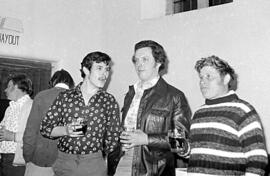
Bampton Traditional Morris Men
- BCA - 2023.4165
- Part
- 1980?
Bernie Basson, Jasper Walsh in jacket, and Cyril Smith on left enjoying a drink at a dance in Alvescot
Janet Westman
5 results directly related Exclude narrower terms
Bampton Traditional Morris Men
Bernie Basson, Jasper Walsh in jacket, and Cyril Smith on left enjoying a drink at a dance in Alvescot
Janet Westman
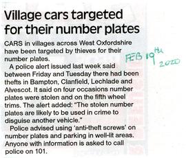
Newspaper cutting reporting thefts of number plates in Bampton Clanfield, Lechlade and Alvescot
Janet Westman

Ordnance Survey Map dated 1922 Grafton to Chimney including villages
Ordnance Survey Map Dated 1922. showing villages from Grafton Clanfield, Alvescot, Bampton south to Thames, Aston, Chimney
There are pencil notes on the map difficult to read'
The places printed on map are as follows
Bampton
Baptist Chapel
Beam Cottage
Bridge Street
Broad Street
Broad Street
Calais Farm
Castle remains
Cheapside
Church Lane
Churchgate House
Coalpit Farm
Deanery Farm
Elephant and Castle
Fishers Bridge
Gas Works
Ham Court
Highmoor Brook
Lady Well
Manor Cottage
Manor House
Mill Barn
Mill Bridge
Mount Owen Farm
New Inn Lane
Old Gravel Pit
Plantation
Primrose Cottages
Sandford Villa
Swan Inn
The Grange
Vicarage
Water Tower
Weald Manor House
Windmill House
Wrights hill
Lower Haddon Farm
Ven Bridge
Elmwood House
Alvescot
Alvescot House
Alvescot Lodge
Alvescot Mill
Alvescot Station
Bates Land Farm
Buxhill Farm
Manor Farm Alvescot
Milestone Road
Old Chapel Pit
Plough Inn
Rectory Farm
Red Lion PH
Royal George PH
Shield Farm
Smithy
St Peters Church
The Rectory
Vine Cottage
Clanfield
Little Clanfield
Grafton Green Farm
Little Clanfield Mill
Manor Farm
Radcot
Radcot New Buildings
Langley Lane
Langford Brook
Ashton Pill Bridge
Swan Inn
Cradle Bridge (Foot)
Radcot Bridge
River Thames
Entrenchment The Garrison
Towing Path
Radcot Lock
Sharney Brook
Burroway Brook
Burroway Bridge
Sharney Bridge
River Thames or Isis
Old Mans Bridge
Clanfield
Manor Farm
Broadwell Brook
Chestlion Farm
Clanfield Weir Farm
Engineering Work
Friar's Court Monastry
Pound Lane
St Stephens
Windmill Farm
Black Bourton
East Gloucestershire Branch Railway
Garsons Copse
High House
Manor Farm
Moat House
St Marys Church
Vicarage
Corn Mill
Lower Farm
Buckland Road
Boat House
Buckland Marsh
Great Brook
Isle of Wight Bridge
Meadow Farm
Tadpole Bridge
Tenfoot Bridge
Aston, Cote and Chimney
Aston House
Bull Inn
Bull Street
Cote House
Cote Lodge
Duckend Farm
Girls Training Home
Ham Lane
Kingsway Farm
North Street
Old Clay Pit
St James Church
Yelford
Claywell Farm
Elmbank
Manor Farm
Newhouse Farm
Rickless Hill
St Swithins Church
Yelford Manor
Ditcham Wood
Rushey Butts
Lew Lodge
Janet Westman

1797 Map showing Bampton Hundred
Map showing Oxfordshire area from Westwell to Curbridge and Kelmscot to Coat (Cote) Common, Bampton Hundred,
plus segment showing St Giles, Oxford.
Published by R. Davis Lewknor August 1797 and indicating:
Alvescot, Asthrop Farm, Aston, Bampton and Aston Fields, Bampton in the Bush, Barley Park, Black Bourton, Brize Norton, Broadwell Grove, Broughton, Burwell Farm, Caswell, Clanfield, Clarks Wier, Claywell, Coat, Curbridge, David Wier, Ducklington, Ducklington, Eaton Hastings, Eaton Hastings, Friars Court, Grafton, Great Lemhill, Harts Wier, Holwell, Kelmscot, Kencote, Langfiord, Lew Barrow, Lew Barrow, Little Clanfield, March Haddon, Nans Wier, Nethber Filkins, New Mill, Ouseham Mill, Over Filkins, Oxley, Radcot, Rushey , Shill Farm, Shilton, Signet, Starvehall Farm, Sworn Leys, Tadpole and Bridge, Ten Foot Wier, Turnpike, Westwell, Witney Park, ,
Janet Westman
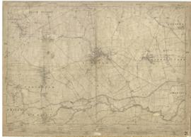
1922 map of Clanfield, Alvescot, Black Bourton, Grafton, Bampton, Aston, Cote & Chimney
This map was produced in 1922 and shows the field system as well as the parliamentary boundaries as at 1918.
There are many interesting notes written on in pencil. The water tower and gas works along the Aston Road were in existence. The allotment gardens NW of Beam Cottage are labelled as is the gravel pit to the SW of Beam Cottage.
There are no houses to the north of New Road and none to the south of it going east from Bushey Row.
Rushy Weir is shown clearly as is the tow path to the south side of the river Thames.
Bampton Community Archive