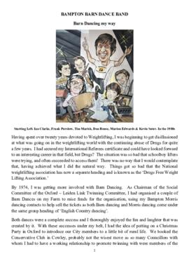
BAMPTON BARN DANCE BAND by Don Rouse
- BCA - 2024.6837
- Item
- 2022
An entertaining history of the Bampton Barn Dance Band by Don Rouse
Janet Newman
117 results with digital objects Show results with digital objects
BAMPTON BARN DANCE BAND by Don Rouse
An entertaining history of the Bampton Barn Dance Band by Don Rouse
Janet Newman

Bampton at Time of the Enclosure Act 1821
These maps are copied from the document housed at St. Luke's Museum, in East Oxford. The Maps show The fish ponds and water courses, the areas of land and boundaries allocated to the Landowners and names of the plots. There are fish ponds marked in grey behind the Grange, by The Deanery, Weald Manor and down Cheyne Lane
Landowners are named as follows
Lord Shrewsbury, Jesus College, Miss CA Horde, H. Willis, L&T Dewe, James Dewe, The Revd G Richards, The Honourable J Coventry, H. Williams Lefsee, Abingdon Poor, Jos Andrews, Catherine Upjohn, Allotment for Tithes, The Dean and Chapter of Exeter, The Rev J Francis, Rev H Owen, W.J. Walker, Bernard Green, E. Whitaker, Josiah Andrews, G. Shingleton, Catherine Upjohn, Jos Barratt Esq, John Roberts , The Rev T Burrow, Swinbrook Charity, The Rev J Francis, John Kenn,
Names of Plots
Werge Furlong, Youngs Close, Pond Close, Cock, Hen and Chick Furlong, Burnthouse Closes, Bedsons Close, Lains Close, Wrights Hill Furlong, The Poor House, Pettifers Close, Kirks Close, Gravel Pits, The Bowling Green, Forty Acres, Grove Orchard, Dr Andrews, Forty Acres Furlong, Hawkins Piece, Lamperts Seven Acres, The Mews, Swinbrook Close, Home Orchard, Lower Orchard, Lissets Close, Fishers Bridge Close, Coppity Ground, Hows's Closes, Grove Orchard, Kirks Close, Clay Close, Little Clay, Landalls Mead, Calved Close, Dickinson Mead, Coneygra, Headland, Ten Acres F, Horse Close, The Knowl, Eight Acres, Barley ground, Eight Acre F, Gullivers Pieces, Rushey Close, Stray Close, Ham Court Orchard, Sandfords, Great Bourn, Watts Close, Bull Green, Furlong Shooting on Clanfield Footpath, Coxeters Furlong, Coxeter Piece, Varnells Furlong, Rake Ready Lane, Home Close, Spring Close, Bull Furlong, Thoroughout Furlong, Clay Furlong, Wright Hill Furlong, Home Orchard,
Janet Westman
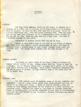
Transcription of the contents of the Domesday Book relating to BAmpton and the surrounding villages including:
Nik Stanbridge
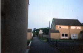
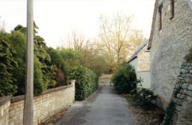
Photos of Alley ways and paths supplied by Andrew Hilditch
Path from The Pieces to Aston Road, Broad Street, west side, Queen St to Bushey Row path by Bampton House
Janet Westman
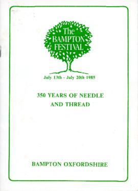
350 years of Needle and Thread: The Bampton Festival
PDF of catalogue for exhibition held for the Festival of Bampton 1985 of embroidery and samplers ranging over 350 years
Janet Westman

1797 Map showing Bampton Hundred
Map showing Oxfordshire area from Westwell to Curbridge and Kelmscot to Coat (Cote) Common, Bampton Hundred,
plus segment showing St Giles, Oxford.
Published by R. Davis Lewknor August 1797 and indicating:
Alvescot, Asthrop Farm, Aston, Bampton and Aston Fields, Bampton in the Bush, Barley Park, Black Bourton, Brize Norton, Broadwell Grove, Broughton, Burwell Farm, Caswell, Clanfield, Clarks Wier, Claywell, Coat, Curbridge, David Wier, Ducklington, Ducklington, Eaton Hastings, Eaton Hastings, Friars Court, Grafton, Great Lemhill, Harts Wier, Holwell, Kelmscot, Kencote, Langfiord, Lew Barrow, Lew Barrow, Little Clanfield, March Haddon, Nans Wier, Nethber Filkins, New Mill, Ouseham Mill, Over Filkins, Oxley, Radcot, Rushey , Shill Farm, Shilton, Signet, Starvehall Farm, Sworn Leys, Tadpole and Bridge, Ten Foot Wier, Turnpike, Westwell, Witney Park, ,
Janet Westman