This map was produced in 1922 and shows the field system as well as the parliamentary boundaries as at 1918. There are many interesting notes written on in pencil. The water tower and gas works along the Aston Road were in existence. The allotment gardens NW of Beam Cottage are labelled as is the gravel pit to the SW of Beam Cottage. There are no houses to the north of New Road and none to the south of it going east from Bushey Row. Rushy Weir is shown clearly as is the tow path to the south side of the river Thames.
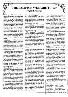
The Bampton Welfare Trust is a local charity that came into its present form thanks to the efforts of Major Robert Colvile in the mid-1970s. He brought together all the ancient charities into one entity , now known as The Bampton Welfare Trust.
letters and information researching into the Spurrett family of Bampton and Aston done c1971 13 page PDF of letters between Sheila and Syd Emm and Mr Hughes Owens. which eventually resulted in a lot of history uncovered and documented in the following link
https://spurrett.uk/home/places/#bampton-oxfordshire The blog post here includes a diagram that may help explain the relationship between the various groupings. The summaries below include the following places (so far): Yorkshire Stow-on-the-Wold Siddington and the Lambourn Downs London Banbury, Oxfordshire Faringdon, Berkshire (now Oxfordshire) Hexham, Northumberland Bampton, Oxfordshire Aston, Oxfordshire
On her 103rd Birthday, 26th Feb 2025, Joyce Anderson donated this small red book to the Bampton Community Archive. The book is entitled "Oxfordshire" written by F.G. Brabant, M.A. Illustrated by Edmund H. New. First published May 1906. This is the third edition – published 1919. These pdfs are excerpts about Bampton in the book, and the book itself is available in our locked cupboard at the Archive should anyone want to view for reference.