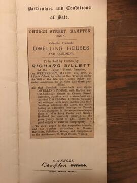
1908 sale of property in Church Street.png
- BCA - 2023.4838
- Item
- 2023
1908 sale of property in Church Street.png
Nik Stanbridge
3407 results with digital objects Show results with digital objects
1908 sale of property in Church Street.png
1908 sale of property in Church Street.png
Nik Stanbridge

1797 Map showing Bampton Hundred
Map showing Oxfordshire area from Westwell to Curbridge and Kelmscot to Coat (Cote) Common, Bampton Hundred,
plus segment showing St Giles, Oxford.
Published by R. Davis Lewknor August 1797 and indicating:
Alvescot, Asthrop Farm, Aston, Bampton and Aston Fields, Bampton in the Bush, Barley Park, Black Bourton, Brize Norton, Broadwell Grove, Broughton, Burwell Farm, Caswell, Clanfield, Clarks Wier, Claywell, Coat, Curbridge, David Wier, Ducklington, Ducklington, Eaton Hastings, Eaton Hastings, Friars Court, Grafton, Great Lemhill, Harts Wier, Holwell, Kelmscot, Kencote, Langfiord, Lew Barrow, Lew Barrow, Little Clanfield, March Haddon, Nans Wier, Nethber Filkins, New Mill, Ouseham Mill, Over Filkins, Oxley, Radcot, Rushey , Shill Farm, Shilton, Signet, Starvehall Farm, Sworn Leys, Tadpole and Bridge, Ten Foot Wier, Turnpike, Westwell, Witney Park, ,
Janet Westman
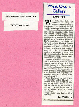
100 exhibits from woodcuts to embroidery and paintings May 2002
100 exhibits from woodcuts to embroidery and paintings May 2002
Nik Stanbridge
100 exhibits from woodcut to embroidery to paintings May 2002
100 exhibits from woodcuts to embroidery to paintings in May 2002 in the Gallery in the Town Hall. Of particular note for the author of the newspaper articles were works by Margaret Charlton's and Jeremy R Jarvis
Bampton Community Archive
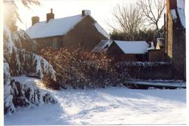
1 and 2 Mill Green before their extension
These little cottages have been extended over the years but seen here, Nos 1 and 2 Mill Green are in their original petite state. A snowy time after Christmas 1981
Bampton Community Archive