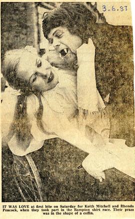
A pair of entrants in the 1983 Shirt Race
- BCA - 2021.2546
- Item
- 1983
Keith Mitchell and Rhona Peacock in fancy dress for the shirt race in 1983. Their pram was made into a coffin on wheels.
Bampton Community Archive
A pair of entrants in the 1983 Shirt Race
Keith Mitchell and Rhona Peacock in fancy dress for the shirt race in 1983. Their pram was made into a coffin on wheels.
Bampton Community Archive
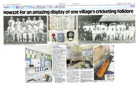
A history of cricket in Bampton
Bampton has had a long history of playing cricket and Anna Pitt put on a wonderful, well researched exhibition on the subject in January/February 2019. The catalogue of the exhibition is still on sale. This is a double spread newspaper article about it that was in the Witney Gazette January 23rd 2019.
Bampton Community Archive

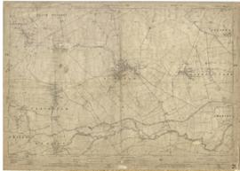
2nd edition maps of 1899 Bampton, Black Bourton, Mt Owen Road
These three maps are all labelled as 2nd edition 1899. They cover the area Central Bampton, north & south, east nearly to Aston, Black Bourton south to Cowleaze Corner, east to Elephant & Castle in Bridge Street and Mt Owen Rd, west to road going up to Lew now called Station Road.
They not only show the buildings but someone has written on in pencil when certain plots were sold and to whom.
Interesting to see the clear fish-farming area with the Deanery then called Deanery Farm, Cobb House simply called Vicarage, Churchgate House called Trinity Vicarage. The third vicarage is today called Kilmore House and is almost opposite the East window of St. Mary's.
What today is called Bridge Street was then called Mill Street and the mill was just to the left of path to Sandford Field from Bridge St. The legend is the mill wheel was buried in the plot to the left of the brook walking to the field from Bridge St and the tree there today was planted at its centre.
Bampton Community Archive
1922 map of Clanfield, Alvescot, Black Bourton, Grafton, Bampton, Aston, Cote & Chimney
This map was produced in 1922 and shows the field system as well as the parliamentary boundaries as at 1918.
There are many interesting notes written on in pencil. The water tower and gas works along the Aston Road were in existence. The allotment gardens NW of Beam Cottage are labelled as is the gravel pit to the SW of Beam Cottage.
There are no houses to the north of New Road and none to the south of it going east from Bushey Row.
Rushy Weir is shown clearly as is the tow path to the south side of the river Thames.
Bampton Community Archive