
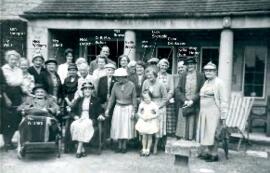
1991 May Queen Julie Kelman, May Day Fair, grand weigh-in, club dinner
- BCA - 2023.6141
- Item
- 2023
1991 May Queen Julie Kelman, May Day Fair, grand weigh-in, club dinner
Nik Stanbridge
1600 results with digital objects Show results with digital objects
1991 May Queen Julie Kelman, May Day Fair, grand weigh-in, club dinner
1991 May Queen Julie Kelman, May Day Fair, grand weigh-in, club dinner
Nik Stanbridge
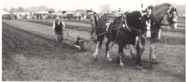
1983 FFF&B Ploughing Match held at Weald Farm
1983 FFF&B Ploughing Match held at Weald Farm
Nik Stanbridge
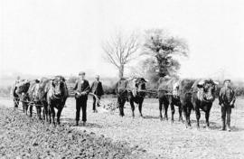
1980, 1982 and 2003 FFF&B Ploughing matches
1980, 1982 and 2003 FFF&B Ploughing matches
Nik Stanbridge
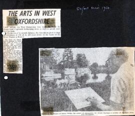
1980 West Ox Arts celebrates its 7th year with an open air event at Radcot Bridge
To mark its 7th year West Ox Arts held an exhibition of 100 of its 250 local artists' work on the banks of the river Thames at Radcot.
Bampton Community Archive

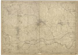
1974 OS map of Bampton and Aston
This Ordinance Survey map was produced in 1974 and covers the area from Hobbs buildings/Deanery Farm in the north, due east to Coal Pit Farm, south to Bampton centre, on south to Weald, east to Aston and south to the Radcot Cut and Great Brook and the Thames.
Bampton Community Archive
1962 Album created by the Darby & Joan Club plus a few photographs
1962 Album created by the Darby & Joan Club plus a few photographs
Nik Stanbridge
1922 map of Clanfield, Alvescot, Black Bourton, Grafton, Bampton, Aston, Cote & Chimney
This map was produced in 1922 and shows the field system as well as the parliamentary boundaries as at 1918.
There are many interesting notes written on in pencil. The water tower and gas works along the Aston Road were in existence. The allotment gardens NW of Beam Cottage are labelled as is the gravel pit to the SW of Beam Cottage.
There are no houses to the north of New Road and none to the south of it going east from Bushey Row.
Rushy Weir is shown clearly as is the tow path to the south side of the river Thames.
Bampton Community Archive

1913 map of Weald, west to Marsh Lane on east edge of Clanfield
This map is from 1913 and covers the area from Marsh Lane on the eastern edge of Clanfield west across Weald. However, all of Bridge Street, half the Talbot Inn, the west side of the Market Square, the South side of Church Street and Church View are all in Weald and they are not shown here, possibly because the map was for agricultural purposes. There are some very interesting notes added in pencil.
Bampton Community Archive

1797 Map showing Bampton Hundred
Map showing Oxfordshire area from Westwell to Curbridge and Kelmscot to Coat (Cote) Common, Bampton Hundred,
plus segment showing St Giles, Oxford.
Published by R. Davis Lewknor August 1797 and indicating:
Alvescot, Asthrop Farm, Aston, Bampton and Aston Fields, Bampton in the Bush, Barley Park, Black Bourton, Brize Norton, Broadwell Grove, Broughton, Burwell Farm, Caswell, Clanfield, Clarks Wier, Claywell, Coat, Curbridge, David Wier, Ducklington, Ducklington, Eaton Hastings, Eaton Hastings, Friars Court, Grafton, Great Lemhill, Harts Wier, Holwell, Kelmscot, Kencote, Langfiord, Lew Barrow, Lew Barrow, Little Clanfield, March Haddon, Nans Wier, Nethber Filkins, New Mill, Ouseham Mill, Over Filkins, Oxley, Radcot, Rushey , Shill Farm, Shilton, Signet, Starvehall Farm, Sworn Leys, Tadpole and Bridge, Ten Foot Wier, Turnpike, Westwell, Witney Park, ,
Janet Westman