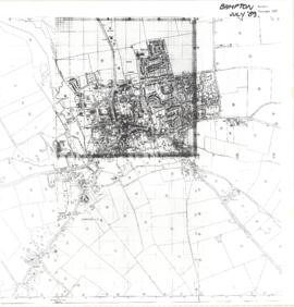
Map of Bampton July 1989 revised 1990
- BCA - 2022.3809
- Item
- 1989-1990
Map Showing extent of Bampton in1989 (revised 1990)
Janet Westman
Map of Bampton July 1989 revised 1990
Map Showing extent of Bampton in1989 (revised 1990)
Janet Westman

Map of Aston & Bampton dated 1773 pre Inclosure Act
Hand drawn Map of showing fields and plots of land with their names in Weald, Bampton, Aston , Yelford and Shifford
The following plot names are included on the map: Aston Cow Common, Aston Sheep Common, Aston Way, Backrills, Badbury F, Bampton Wwstmoor Cow Common, Barnes F, Barow Laynes, Barrow Hill Furlong, Belham, Broad Close, Brook Eight Acres, Brookfast Furlong, Bush Furlong, Cabbage Mead, Calcraft Lane, Calcraft Paddocks, Calves Close, Carters Ham, Charney Meadow, Chimney, Church Field, Claye well Field, Clyell Furlong, Coae Moor Furlong, Coate Town, Columbine, Combe Hill Common, Corn Benny, Cornborn Mead, Cornburn Mead, Cottage Close or Cow Common, Cow Lease Furlong, Craze Acres, Cricklade Ham, Cripps F, Culvery F, Dales Middle East Hery, Dean Mill Furlong, Drove Close, Duxford East Hey, Esq Horde House, Farres First East Hey, Fore Mead, Fore Meadow, Fox Close, Foxes, Fross Furlong, Further Ash Close, Furths Edgerley F, Gander Fields, Garsons Field, Gaston Field, Green Close, Grafton Green, Grandmothers, Great Harnett Close, Great Hillingworth F, Great Nipham belonging to Duke of Marlbporough, Great Rushia, Green Benny F, Grrat Hell, Ham End Furlong, Hatchway Close, Hayway Furlong, Hesters Ground, Highmoor Meadow, Hilley Tithe, Hilly Lease, Holley Well Field, Home Covet, Home F, Home Rushia, Home Rushia, Kingsway Field, LaneCloses, Lanes Furlong, Langley Meadow, Laping Lands, Large Peece, Little Furzy, Little Harnett Close, Little Hell, Long Kendle , Long Lane, Long Sunderwell, Long Wood Furlong, Longlands Farm, Lower Bainey, Lower Cripps Piece, Marsh Long F, Mawbrook, May Furlong, Mead Furlong, Meadow or Elder Stump F, Middlefield, Mill F, Moor Furlong, Moors, Norloins, Oate F, Over Redlands, Pantins, Parsons Hedge Field, Perseland, Pissa Bed Furlong, Poulsworth Common Field, Pullins Piece, Rake Ready Lane, Redlands Farm, Rey Furlong, Rickley Hill, Rye Meadow, Shephouse Paddock, Shifford Common, Short Beer Furong, Short Hedge Furlong, Shortwood F, Shotton Fishermans Hedge, Showells Mead, Sidwell Close, Skinners F, Southby's Great East Hey, Spade Furlong, Sparkes Close, Spile Close, Stack Furlong, Stamps East Hey, Stocks Close, Stocks Lains F, Stone Acre, Swift Lake, Tanny Marsh, The Great Bourne, The Hakles, The Knoll, The Maths, Thirstle Reese, Thorney Lease, Town F, Turnpike Road, Upper Bainey and half Yard Mead, Upwell Grounds, Weed Furlong, Welshmans Acre, Westmoor Lane, Windmill, Wolands F, Wrights or Mill Field, Wymonds Place, Yard and half Mead, Youngs Close Furlong,
Janet Westman
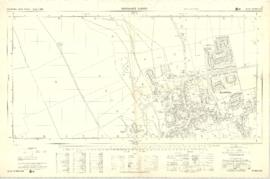
Ordnance Survey Plan SP3003-3103. Bridge St east Colvile Close etc 1971
This Ordnance Survey Plan SP3003-3103. Dated 1971 shows area
Bridge St east to end of houses, north to new school, Colvile Close etc
Properties and Streets listed :
Air Training Corps
Ampney Lodge
Apple Tree Cottage
April Cottage
Army cadet Hut
Bakery
Bampton House
Bay Tree Cottage
Belgrave Cottage
Blackthorn Cottage
Blackthorn Cottagre
Bourton Cottage
Box House
Bushey House
Calais Farm
Cheapside
Chestnuts
Churchgate House
Churchgate House
Clevelly
Cobb House
Corner Cottage
Cornmill
Cotsway
Cotswold Lodge
Courtlands
Dairy Farm House
Deanery Farm
Down Home
Elephant and Castle
Eton Villas
Felix Cottage
Fernlea
Field Cottage
Fishers Bridge
Fleur de Lys
Folly House
Folly View
Fox Close
George and Dragon
Grayshot House
Ham Court
Haytor House
Highmoor Brook
Inglenook Cottage
Kilmore House
Kilmore House
Landells
Leighton Cottage
Lester House
Library
Lime Tree House
Little Pinkneys
Little Place Cottage
Littlemead
Lynton Mead
Mallows
Manor House
Matthew House
Melita
Moss Rose Cottage
Oathurst Estate
Plantation
Pococks Close
Police Office
Poplar Cottage
Primrose Cottages
Priory Cottage
Prospect Cottage
Prospect House
Prospect Place
Quebec Cottage
Rhandom
Roseann
Rosebrook
Rosemary House
San Toy
Sandford House
Southrop House
Southside
St Johns House
St Oswald
Sunnyside Cottage
Thatched Cottage
The Bungalow
The Deanery
The Eagle
The Elms
The Gate Cottage
The Glen
The Grange
The Grey House
The Haven
The Hermitage
The Horse Shoe
The Jubilee
The Malt Shovel
The Old Forge
The Vicarage
The Yews
Town Hall
Tudor Cottage
Turnings
Vaizey Cottage
Vicarage
Victoria Cottages
Vine Cottage
Weald Manor House
Wheelgate House
Windsmore
Windsor Cottagres
Yew Tree Cottage
Youth Club
Ampney Orchard
Aston Road
Bowling Green Close
Bridge Street
Broad Street
Buckland Road
Bushey Row
Chandler Close
Cheapside
Church Lane
Church Street
Church View
Colvile Close
Glebelands
High Street
High Street
Lavender Square
Manor View
Mercury Close
New Road
Queens Street
Rosemary Lane
Janet Westman

Ordnance Survey Plan SP3002-3102 1971. Cowleaze Corner Weald to Aston Road
Ordnance Survey Plan SP3002-3102 dated 1971. Cowleaze Corner, Weald to Aston, north to Horse Shoe
and showing the following places and buildings
Ashtree
Aulnoy
Backhouse Farm
Bournemead
Brook Farm
Brook House
Buckland Road
Caravan Park
Cheyne Lane
Clanfield Road
College Farm House
Corner Farm
Cowleaze Corner
Cricket Field
Dunlaoghaire
Fisher's Bridge
Gate Cottage
Glebe Cottage
Glebe Farm
Ham Court
Ham Court Cottages
Highmoor House
Knapps Farm
Lime Tree Cottages
Mill Bridge
Mill Green
Orchard Cottage
Primrose Cottages
Rose Cottage
Shill Brook
Shrangi-la
Spring Cottages
St Frideswide
Stable Cottage
Sunny view
Sunnyside
Thatch Cottage
The Bungalow
The Lodge
The Old Farmhouse
Weald Farm
Weald Farm Cottages
Weald Manor
Weald Manor Cottage
Weald Manor Farm
Janet Westman

Plan of the Lew Estate, Oxfordshire divided into coloured sections/Lots for sale by auction by Messrs Knight, Frank and Rutley .
Janet Westman