The map is pre Inclosure and covers Clanfield, Bampton, Aston and Yelford. The note with the Yelford map says it was from a map of 1624/5. A note at the right side of the page suggests all these details were pulled together from various sources in 1833 which is post Inclosure, which for the Bampton area was 1821. I can't work out what maps were used for the non-Yelford map but it says HHH is Aston 1771.
In October 2012 the Bampton Environmental Watch Group had a wonderful talk given by John Leighfield on the history of maps and in particular maps of Oxfordshire and Bampton. It was very interesting to note that the first maps of Bampton showed the rivers and streams but no roads, showing the importance of waterways. It really is worth looking at the maps of Bampton carefully, you'll see just how old some buildings are, where the mill was in Bampton and Kerwoods Yard which was one area for the very poor with dwellings that had no land with them, they afforded the occupier a roof as opposed to 'the park bench' but no land on which to produce any food. It's referred to in early census forms and people come to Bampton asking where it is - it's on page 15 of this pdf
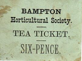
This ticket for a tea was found in a pile of bits and pieces when clearing out a garage. Teas were sold to raise funds for the Bampton Horticultural Society. The cost was 6 pence in old money - 6d - so pre decimalisation of February 1971.