Showing 445 results

Archival description
Item Bampton General
Print preview View:

438 results with digital objects Show results with digital objects

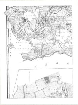
1797 Map showing Bampton Hundred

  • BCA - 2022.3819
  • Item
  • 1797

Map showing Oxfordshire area from Westwell to Curbridge and Kelmscot to Coat (Cote) Common, Bampton Hundred,
plus segment showing St Giles, Oxford.
Published by R. Davis Lewknor August 1797 and indicating:
Alvescot, Asthrop Farm, Aston, Bampton and Aston Fields, Bampton in the Bush, Barley Park, Black Bourton, Brize Norton, Broadwell Grove, Broughton, Burwell Farm, Caswell, Clanfield, Clarks Wier, Claywell, Coat, Curbridge, David Wier, Ducklington, Ducklington, Eaton Hastings, Eaton Hastings, Friars Court, Grafton, Great Lemhill, Harts Wier, Holwell, Kelmscot, Kencote, Langfiord, Lew Barrow, Lew Barrow, Little Clanfield, March Haddon, Nans Wier, Nethber Filkins, New Mill, Ouseham Mill, Over Filkins, Oxley, Radcot, Rushey , Shill Farm, Shilton, Signet, Starvehall Farm, Sworn Leys, Tadpole and Bridge, Ten Foot Wier, Turnpike, Westwell, Witney Park, ,

Janet Westman

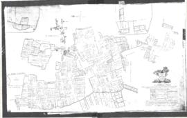
Map of Bampton Estate at 1789

  • BCA - 2019.1890
  • Item
  • 1789

This map shows the Bampton Estates at 1789. This is before the fields were enclosed and the names of the people who farmed the strips or the name of the field area are on the map. The Quies fields are each side of the Bampton to Brize Norton road, just north of what is now Hobbs Buildings.
The Clanfield to Bampton road is showing top to bottom on the map whereas it really runs east west, so you need to get your head around that, literally.
What we now call Welcome Way is called Wiltham Way - it runs south from Cowleaze Corner into Weald.
Weald Common Meadow was south of what we now think of as the area containing the two Bampton Business Parks.
The Bampton to Buckland road is showing going left to right on the map when it actually runs NW to SE; it had a turnpike.

Bampton Community Archive

Map of Aston & Bampton dated 1773 pre Inclosure Act

  • BCA - 2022.3817
  • Item
  • 1773

Hand drawn Map of showing fields and plots of land with their names in Weald, Bampton, Aston , Yelford and Shifford
The following plot names are included on the map: Aston Cow Common, Aston Sheep Common, Aston Way, Backrills, Badbury F, Bampton Wwstmoor Cow Common, Barnes F, Barow Laynes, Barrow Hill Furlong, Belham, Broad Close, Brook Eight Acres, Brookfast Furlong, Bush Furlong, Cabbage Mead, Calcraft Lane, Calcraft Paddocks, Calves Close, Carters Ham, Charney Meadow, Chimney, Church Field, Claye well Field, Clyell Furlong, Coae Moor Furlong, Coate Town, Columbine, Combe Hill Common, Corn Benny, Cornborn Mead, Cornburn Mead, Cottage Close or Cow Common, Cow Lease Furlong, Craze Acres, Cricklade Ham, Cripps F, Culvery F, Dales Middle East Hery, Dean Mill Furlong, Drove Close, Duxford East Hey, Esq Horde House, Farres First East Hey, Fore Mead, Fore Meadow, Fox Close, Foxes, Fross Furlong, Further Ash Close, Furths Edgerley F, Gander Fields, Garsons Field, Gaston Field, Green Close, Grafton Green, Grandmothers, Great Harnett Close, Great Hillingworth F, Great Nipham belonging to Duke of Marlbporough, Great Rushia, Green Benny F, Grrat Hell, Ham End Furlong, Hatchway Close, Hayway Furlong, Hesters Ground, Highmoor Meadow, Hilley Tithe, Hilly Lease, Holley Well Field, Home Covet, Home F, Home Rushia, Home Rushia, Kingsway Field, LaneCloses, Lanes Furlong, Langley Meadow, Laping Lands, Large Peece, Little Furzy, Little Harnett Close, Little Hell, Long Kendle , Long Lane, Long Sunderwell, Long Wood Furlong, Longlands Farm, Lower Bainey, Lower Cripps Piece, Marsh Long F, Mawbrook, May Furlong, Mead Furlong, Meadow or Elder Stump F, Middlefield, Mill F, Moor Furlong, Moors, Norloins, Oate F, Over Redlands, Pantins, Parsons Hedge Field, Perseland, Pissa Bed Furlong, Poulsworth Common Field, Pullins Piece, Rake Ready Lane, Redlands Farm, Rey Furlong, Rickley Hill, Rye Meadow, Shephouse Paddock, Shifford Common, Short Beer Furong, Short Hedge Furlong, Shortwood F, Shotton Fishermans Hedge, Showells Mead, Sidwell Close, Skinners F, Southby's Great East Hey, Spade Furlong, Sparkes Close, Spile Close, Stack Furlong, Stamps East Hey, Stocks Close, Stocks Lains F, Stone Acre, Swift Lake, Tanny Marsh, The Great Bourne, The Hakles, The Knoll, The Maths, Thirstle Reese, Thorney Lease, Town F, Turnpike Road, Upper Bainey and half Yard Mead, Upwell Grounds, Weed Furlong, Welshmans Acre, Westmoor Lane, Windmill, Wolands F, Wrights or Mill Field, Wymonds Place, Yard and half Mead, Youngs Close Furlong,

Janet Westman

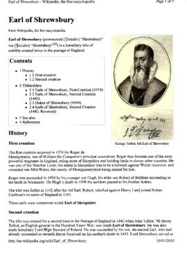
George Talbot, The 6th Earl of Shrewsbury 1528-1590

  • BCA - 2022.3811
  • Item
  • 1528-1590

George Talbot the 6th Earl of Shrewsbury, was the only son of Francis Talbot, 5th Earl of Shrewsbury and Mary Dacre. As a young man George saw military service under Protector Somerset in the ‘Rough Wooings’ in Scotland and he married Gertrude Manners, daughter of the 1st Earl of Rutland, by whom he had six children, although she died in 1566. In March 1568, he married Bess of Hardwick, the wealthy widow of Sir William Cavendish of Chatsworth, who was a year older than himself.
The first creation of Earl of Shrewsbury occurred in 1074 for Roger de Montgomerie, one of William the Conqueror's principal counsellors. Roger thus became one of the most powerful magnates in England, ruling most of Shropshire and holding lands in eleven other counties, and included most of Bampton which continued to belong to the family through future generations.
Roger was succeeded in 1094 by his younger son Hugh, his elder son Robert of Belléme succeeding to his lands in Normandy. On Hugh's death in 1098 the earldom passed to his brother Robert.
More information about the Earls of Shrewsbury can be found in the pdf attached.

Janet Westman

Cheapside 1950

  • BCA - 2022.3837
  • Item
  • 1950

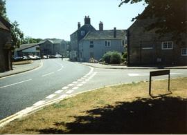
Photograph of Market Square taken from Eton Cottages, showing Town Hall, Garage, Newsagent, Cromwell House and the Old Forge

Janet Westman

Results 441 to 445 of 445