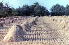
Binder, corn sheaves on Andy Bowman's farm
- BCA - 2021.3166
- Item
- 2021
Binder, corn sheaves on Andy Bowman's farm. Photos by Adrian Simmonds
Nik Stanbridge
67 results with digital objects Show results with digital objects
Binder, corn sheaves on Andy Bowman's farm
Binder, corn sheaves on Andy Bowman's farm. Photos by Adrian Simmonds
Nik Stanbridge

The map was produced in 1921. The first map is has been reused to show where council houses were to be built on the south side of New Road and where the sewerage pipes were to be laid to the sewerage works along the Buckland Road.
Mains sewerage came to Bampton in 1958 after a long struggle and at a cost of £105,000. Miss Marjorie Pollard was the driving force but in the end, it was the death of Horace Morse who emptied the 'night soil' buckets twice a week which made it imperative. Jack Bellinger was the first manager of the sewerage works.
Bampton Community Archive

Bampton at Time of the Enclosure Act 1821
These maps are copied from the document housed at St. Luke's Museum, in East Oxford. The Maps show The fish ponds and water courses, the areas of land and boundaries allocated to the Landowners and names of the plots. There are fish ponds marked in grey behind the Grange, by The Deanery, Weald Manor and down Cheyne Lane
Landowners are named as follows
Lord Shrewsbury, Jesus College, Miss CA Horde, H. Willis, L&T Dewe, James Dewe, The Revd G Richards, The Honourable J Coventry, H. Williams Lefsee, Abingdon Poor, Jos Andrews, Catherine Upjohn, Allotment for Tithes, The Dean and Chapter of Exeter, The Rev J Francis, Rev H Owen, W.J. Walker, Bernard Green, E. Whitaker, Josiah Andrews, G. Shingleton, Catherine Upjohn, Jos Barratt Esq, John Roberts , The Rev T Burrow, Swinbrook Charity, The Rev J Francis, John Kenn,
Names of Plots
Werge Furlong, Youngs Close, Pond Close, Cock, Hen and Chick Furlong, Burnthouse Closes, Bedsons Close, Lains Close, Wrights Hill Furlong, The Poor House, Pettifers Close, Kirks Close, Gravel Pits, The Bowling Green, Forty Acres, Grove Orchard, Dr Andrews, Forty Acres Furlong, Hawkins Piece, Lamperts Seven Acres, The Mews, Swinbrook Close, Home Orchard, Lower Orchard, Lissets Close, Fishers Bridge Close, Coppity Ground, Hows's Closes, Grove Orchard, Kirks Close, Clay Close, Little Clay, Landalls Mead, Calved Close, Dickinson Mead, Coneygra, Headland, Ten Acres F, Horse Close, The Knowl, Eight Acres, Barley ground, Eight Acre F, Gullivers Pieces, Rushey Close, Stray Close, Ham Court Orchard, Sandfords, Great Bourn, Watts Close, Bull Green, Furlong Shooting on Clanfield Footpath, Coxeters Furlong, Coxeter Piece, Varnells Furlong, Rake Ready Lane, Home Close, Spring Close, Bull Furlong, Thoroughout Furlong, Clay Furlong, Wright Hill Furlong, Home Orchard,
Janet Westman
Backhouse Farm, Weald Street 1991
Backhouse Farm, Weald Street 1990 or 91
Fire, geese, straw
Nik Stanbridge
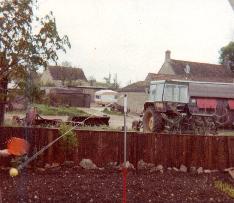
Backhouse Farm and St Mary's Trailer Court, 1989
Backhouse Farm & St Mary's Trailer Court 1989
Eric Hilditch
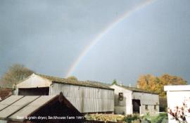
Barn & Grain drier, Backhouse farm 1989
Nik Stanbridge
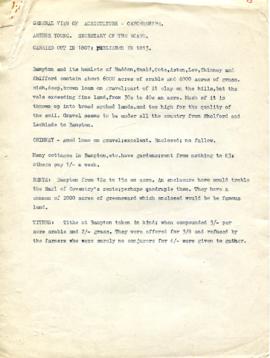
Agriculture in Bampton, Haddon, Weald, Cote, Aston, Lew, Chimney and Shifford (1807)
General View of Agriculture in Oxon carried out in 1807 published 1813. A general view of agriculture in Oxfordshire carried out in 1807 and published in 1813.
Rates, thrashing mills and tillage. Drilling, wheat, beans and tares. Cattle and Labour.
Nik Stanbridge
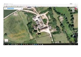
Aerial view of Ham Court before Emma Bridgwater alterations
Aerial view of Ham Court before Emma Bridgwater alterations
Nik Stanbridge
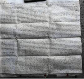
This Indenture on Vellum records :-A Release from William Thomas and Hester his Wife of Lands in Bampton Oxfordshire to Francis Sims Dated the Thirteenth day of June 1735.
Bampton Community Archive

A General View of Agriculture in Oxfordshire
A general view of agriculture in Oxfordshire carried out in 1807 and published in 1813. Rates, thrashing mills and tillage. Drilling, wheat, beans and tares. Cattle and Labour. Relating to Bampton and its hamlets, Haddon, Weald, Cote, Aston, Lew, Chimney and Shifford. Report is written by Arthur Young and seems to use Mr. Singleton of Bampton as an example of of how things were done.
Janet Westman

2nd edition maps of 1899 Bampton, Black Bourton, Mt Owen Road
These three maps are all labelled as 2nd edition 1899. They cover the area Central Bampton, north & south, east nearly to Aston, Black Bourton south to Cowleaze Corner, east to Elephant & Castle in Bridge Street and Mt Owen Rd, west to road going up to Lew now called Station Road.
They not only show the buildings but someone has written on in pencil when certain plots were sold and to whom.
Interesting to see the clear fish-farming area with the Deanery then called Deanery Farm, Cobb House simply called Vicarage, Churchgate House called Trinity Vicarage. The third vicarage is today called Kilmore House and is almost opposite the East window of St. Mary's.
What today is called Bridge Street was then called Mill Street and the mill was just to the left of path to Sandford Field from Bridge St. The legend is the mill wheel was buried in the plot to the left of the brook walking to the field from Bridge St and the tree there today was planted at its centre.
Bampton Community Archive