VIDEO: Albert Chambers. His memories of being an evacuee to Clanfield
- BCA - 2024.6965
- Item
- 2024
Albert Chambers. His memories of being an evacuee to Clanfield
Nik Stanbridge
8 results directly related Exclude narrower terms
VIDEO: Albert Chambers. His memories of being an evacuee to Clanfield
Albert Chambers. His memories of being an evacuee to Clanfield
Nik Stanbridge

Ted Fenton: Conservative Candidate
Conservative Flyer for Ted Fenton, District Council Candidate for Bampton, Clanfield and Black Bourton. This was for the West Oxfordshire District Council Election to be held on Thursday 4th May 2023.
Janet Westman

Liberal Democrat - Alaric Smith letter Housing
Copy of circular sent by Alaric Smith, Liberal Democrat Councillor for Bampton and Clanfield, re the threat of speculative development in the local community.
Janet Westman

Ted Fenton WODC Election May 2019
Electoral Flyer for West Oxfordshire District Council Election for Ted Fenton. Local Conservative Candidate for Bampton and Clanfield May 2 2019
Janet Westman
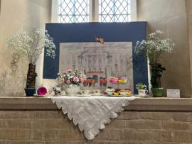
46 images of beautiful flower arrangements in St Stephens Church Clanfield. to commemorate Queens 70th year on the throne.
Janet Westman

Ordnance Survey Map dated 1922 Grafton to Chimney including villages
Ordnance Survey Map Dated 1922. showing villages from Grafton Clanfield, Alvescot, Bampton south to Thames, Aston, Chimney
There are pencil notes on the map difficult to read'
The places printed on map are as follows
Bampton
Baptist Chapel
Beam Cottage
Bridge Street
Broad Street
Broad Street
Calais Farm
Castle remains
Cheapside
Church Lane
Churchgate House
Coalpit Farm
Deanery Farm
Elephant and Castle
Fishers Bridge
Gas Works
Ham Court
Highmoor Brook
Lady Well
Manor Cottage
Manor House
Mill Barn
Mill Bridge
Mount Owen Farm
New Inn Lane
Old Gravel Pit
Plantation
Primrose Cottages
Sandford Villa
Swan Inn
The Grange
Vicarage
Water Tower
Weald Manor House
Windmill House
Wrights hill
Lower Haddon Farm
Ven Bridge
Elmwood House
Alvescot
Alvescot House
Alvescot Lodge
Alvescot Mill
Alvescot Station
Bates Land Farm
Buxhill Farm
Manor Farm Alvescot
Milestone Road
Old Chapel Pit
Plough Inn
Rectory Farm
Red Lion PH
Royal George PH
Shield Farm
Smithy
St Peters Church
The Rectory
Vine Cottage
Clanfield
Little Clanfield
Grafton Green Farm
Little Clanfield Mill
Manor Farm
Radcot
Radcot New Buildings
Langley Lane
Langford Brook
Ashton Pill Bridge
Swan Inn
Cradle Bridge (Foot)
Radcot Bridge
River Thames
Entrenchment The Garrison
Towing Path
Radcot Lock
Sharney Brook
Burroway Brook
Burroway Bridge
Sharney Bridge
River Thames or Isis
Old Mans Bridge
Clanfield
Manor Farm
Broadwell Brook
Chestlion Farm
Clanfield Weir Farm
Engineering Work
Friar's Court Monastry
Pound Lane
St Stephens
Windmill Farm
Black Bourton
East Gloucestershire Branch Railway
Garsons Copse
High House
Manor Farm
Moat House
St Marys Church
Vicarage
Corn Mill
Lower Farm
Buckland Road
Boat House
Buckland Marsh
Great Brook
Isle of Wight Bridge
Meadow Farm
Tadpole Bridge
Tenfoot Bridge
Aston, Cote and Chimney
Aston House
Bull Inn
Bull Street
Cote House
Cote Lodge
Duckend Farm
Girls Training Home
Ham Lane
Kingsway Farm
North Street
Old Clay Pit
St James Church
Yelford
Claywell Farm
Elmbank
Manor Farm
Newhouse Farm
Rickless Hill
St Swithins Church
Yelford Manor
Ditcham Wood
Rushey Butts
Lew Lodge
Janet Westman
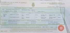
Conveyance of South Terrace and Wedding Cert. Joan Willmer and Ernest Pocock
Marriage Certificate of Ernest Allen Pocock of Yew Tree Farm, Clanfield and Joan Barnard Willmer of Friars Court , Clanfield.
Their Fathers Allen William Pocock and Richard Newman Willmer were both farmers.
They married at the Methodist Chapel in Clanfield AR Hopkins, was Minister and Harry A Steptoe was Registrar. 1951.
Abstract of the title of Mrs Mary Elizabeth Willmer dated 1959 and Conveyance of South Terrace, Weald - a piece of land where a group of 6 cottages once stood.
Janet Westman

Pre Inclosure map of Clanfield, Bampton, Aston & Yelford
The map is pre Inclosure and covers Clanfield, Bampton, Aston and Yelford. The note with the Yelford map says it was from a map of 1624/5. A note at the right side of the page suggests all these details were pulled together from various sources in 1833 which is post Inclosure, which for the Bampton area was 1821. I can't work out what maps were used for the non-Yelford map but it says HHH is Aston 1771.
Bampton Community Archive