- BCA - 2023.6652
- Item
- 2023
Old Map of Public Footpaths in Bampton with list of names short description and width if known and location researched by TE Crowley
Nik Stanbridge
2 results directly related Exclude narrower terms
Old Map of Public Footpaths in Bampton with list of names short description and width if known and location researched by TE Crowley
Nik Stanbridge

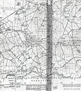
Ordnance Survey Plan SP3203-3303. 1971 Mt Owen Rd east inc. Gogg Lane, Aston Road to Aston
Ordnance Survey Plan SP3203-3303. 1971 Extending from Mt Owen Rd east inc. Gogg Lane, Aston Road and part of Aston. showing the following places:
New Road
White Owl Farm
Bradshaw Close
Kenlincott
Kiln Close
Back Lane
Greenacres Lane
Elmside
Barry House
Ferndale
Back Cottage
Byeways
Laundry Lane
Kingsway Farm
High Street West End
The Limes
West End Farm
Home Farm House
Greens Row
Elvina
Aston Ditch
Mercury Close
Beam Cottage
Old Gasworks Building
New Road
The Willows
St Andrews
Janet Westman