Hilda Kent Artwork

The Lew Estate 1914

Ordnance Survey Map dated 1922 Grafton to Chimney including villages

Lower Haddon Farm 1949 Auction Maps

Ordnance Survey Plan SP3203-3303. 1971 Mt Owen Rd east inc. Gogg Lane, Aston Road to Aston

Ordnance Survey PlanSP3002-3102 Weald, Hayway Lane, Weald St, Clanfield Rd. 1971

1797 Map showing Bampton Hundred
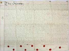
Indenture made May 10th 1808

Bampton at Time of the Enclosure Act 1821

Map of Aston & Bampton dated 1773 pre Inclosure Act