

Identity area
Reference code
BCA - 2022.3827
Title
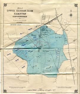
Lower Haddon Farm 1949 Auction Maps
Date(s)
- 1949 (Creation)
Level of description
Item
Extent and medium
JPGs x 2
Context area
Name of creator
Biographical history
Archival history
Immediate source of acquisition or transfer
Content and structure area
Scope and content
two maps - A Plan of Lower Hadden Farm from the Auction held in March 1949, and a hand drawn map of same area
Auctioneers were Jackson-Stops (Cirencester)
With hand written field names as follows
Bampton Station Fairford to Oxford GWR
Barnleys Pasture
Big Barleys
Big Row
Black Bourton Road
Bowlie Ground
Bridle Path to Black Bourton
Bridle Road
Broad Close
Cow Leas
Far Hill
Far Limber
Front Field
Furse Hill
Harps
Highmoor Brook
Home Close
Horn Ground
James' Meadow
Little Barleys
Long Meadow
Lower Hadden Farm
Middle Hill
Mill Barn Copse
Near Barleys
Near Limber
Pike Ground
Pond Gardens
Rogers Meadow
Rushey Row
Smart Hill
The Big Monk
Water Meadows
Willow Beds