
Map of Aston & Bampton dated 1773 pre Inclosure Act

Bampton at Time of the Enclosure Act 1821
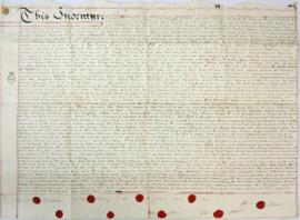
Indenture made May 10th 1808

Lower Haddon Farm 1949 Auction Maps

Ordnance Survey Plan SP3002-3102 1971. Cowleaze Corner Weald to Aston Road

Ordnance Survey Map dated 1922 Grafton to Chimney including villages

The Lew Estate 1914
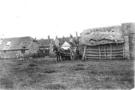
Farm in Bampton early 20th century next to the Deanery
Ploughing Match FFF&B 1980
The Development of Printed Maps of Oxfordshire: From GOUGH to Google
The Development of Printed Maps of Oxfordshire: From GOUGH to Google