Bampton Meadows to be built bottom on Mt Owen Road, East side
- BCA - 2023.4846
- Item
- 2023
Bampton Meadows to be built bottom on Mt Owen Road, East side
Nik Stanbridge
5 results with digital objects Show results with digital objects
Bampton Meadows to be built bottom on Mt Owen Road, East side
Bampton Meadows to be built bottom on Mt Owen Road, East side
Nik Stanbridge
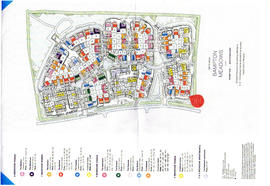
Bampton Meadows Taylor Wimpey Houses
PDF plan of the new houses and showing the Names of the Roads
Radband Nook
Dixey Crescent
Collett Drive
Dor Close
Andrews Way
Jingy Wells Drive
Cambria Mews
Constable Place
Janet Westman

Ordnance Survey Plan SP3203-3303. 1971 Mt Owen Rd east inc. Gogg Lane, Aston Road to Aston
Ordnance Survey Plan SP3203-3303. 1971 Extending from Mt Owen Rd east inc. Gogg Lane, Aston Road and part of Aston. showing the following places:
New Road
White Owl Farm
Bradshaw Close
Kenlincott
Kiln Close
Back Lane
Greenacres Lane
Elmside
Barry House
Ferndale
Back Cottage
Byeways
Laundry Lane
Kingsway Farm
High Street West End
The Limes
West End Farm
Home Farm House
Greens Row
Elvina
Aston Ditch
Mercury Close
Beam Cottage
Old Gasworks Building
New Road
The Willows
St Andrews
Janet Westman
Part of Bampton in 1991: A photographic record by Andrew Hilditch
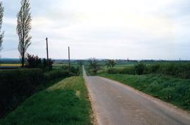
This picture shows the view down Mount Owen road. The spire of Saint Mary The Virgin church is visible on the skyline and the yellow crop of oilseed rape tells us it is April in 1991

2nd edition maps of 1899 Bampton, Black Bourton, Mt Owen Road
These three maps are all labelled as 2nd edition 1899. They cover the area Central Bampton, north & south, east nearly to Aston, Black Bourton south to Cowleaze Corner, east to Elephant & Castle in Bridge Street and Mt Owen Rd, west to road going up to Lew now called Station Road.
They not only show the buildings but someone has written on in pencil when certain plots were sold and to whom.
Interesting to see the clear fish-farming area with the Deanery then called Deanery Farm, Cobb House simply called Vicarage, Churchgate House called Trinity Vicarage. The third vicarage is today called Kilmore House and is almost opposite the East window of St. Mary's.
What today is called Bridge Street was then called Mill Street and the mill was just to the left of path to Sandford Field from Bridge St. The legend is the mill wheel was buried in the plot to the left of the brook walking to the field from Bridge St and the tree there today was planted at its centre.
Bampton Community Archive