1980, 1982 and 2003 FFF&B Ploughing matches
- BCA - 2021.3157
- Item
- 2021
1980, 1982 and 2003 FFF&B Ploughing matches
Nik Stanbridge
204 results with digital objects Show results with digital objects
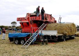
1980, 1982 and 2003 FFF&B Ploughing matches
1980, 1982 and 2003 FFF&B Ploughing matches
Nik Stanbridge

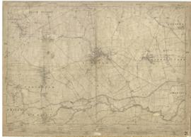
1974 OS map of Bampton and Aston
This Ordinance Survey map was produced in 1974 and covers the area from Hobbs buildings/Deanery Farm in the north, due east to Coal Pit Farm, south to Bampton centre, on south to Weald, east to Aston and south to the Radcot Cut and Great Brook and the Thames.
Bampton Community Archive
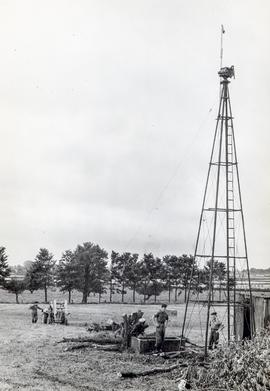
1965 A pylon that once held a windmill on White Owl Farm
This pylon was the framework that once held a windmill on White Owl farm. The farm belonged to Bert and Ted Wilkins.
Bampton Community Archive
1922 map of Clanfield, Alvescot, Black Bourton, Grafton, Bampton, Aston, Cote & Chimney
This map was produced in 1922 and shows the field system as well as the parliamentary boundaries as at 1918.
There are many interesting notes written on in pencil. The water tower and gas works along the Aston Road were in existence. The allotment gardens NW of Beam Cottage are labelled as is the gravel pit to the SW of Beam Cottage.
There are no houses to the north of New Road and none to the south of it going east from Bushey Row.
Rushy Weir is shown clearly as is the tow path to the south side of the river Thames.
Bampton Community Archive

1913 map of Weald, west to Marsh Lane on east edge of Clanfield
This map is from 1913 and covers the area from Marsh Lane on the eastern edge of Clanfield west across Weald. However, all of Bridge Street, half the Talbot Inn, the west side of the Market Square, the South side of Church Street and Church View are all in Weald and they are not shown here, possibly because the map was for agricultural purposes. There are some very interesting notes added in pencil.
Bampton Community Archive