Showing 3 results

Archival description
Plantation
Print preview View:

3 results with digital objects Show results with digital objects

Maps of East Half of Bampton 1921

  • BCA - 2022.3814
  • Item
  • 1921

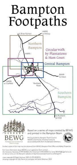
3 Large ordnance Survey Maps used by Hadgood and Mammatt Auctioneers and Estate Agents from Witney. Published in 1921 price £5/- and £6/8d. Points of interest are Highmoor Brook, Plantation, Ham Court, Deanery Farm, Churchgate, Vicarage, Manor House, and Weald Manor House, old gravel pit and Beam Cottage, Calais Farm, Primrose Cottages, Fisher's Bridge

Janet Westman

Map of Bampton Footpaths (2003)

  • BCA - 2022.3751
  • Item
  • 2003

Leaflet showing public footpaths in and around Bampton created in 2003 based on a series of maps created by BEWG (Bampton Environmental Watch Group).

Maps and drawings by Jo Lewington, Gilly Marsh and Janet Westman.

Nik Stanbridge

Circular Walk Map - Plantation and Ham Court

  • BCA - 2023.4097
  • Item
  • 2000?

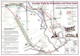
Map of circular walk around Bampton which goes through Plantation and around Ham Court to Clanfield Road
names old fields and meadows i.e. Ham Field, Long Hedge Furlong, Turf Close, Shill Brook, Peeks Ham Close, Norloin's Furlon,
High Moor Meadow, Hilly Leaze

Janet Westman