Showing 6 results

Archival description
Weald Agriculture and Farming Text With digital objects
Print preview View:
1913 map of Weald, west to Marsh Lane on east edge of Clanfield
Map of Weald from Plantation south to Cowleaze Corner, east to the Elephant & Castle
Map 1913 Edition  Marsh Lane East incl Weald and Clanfield Road
Map 1913 Edition Marsh Lane East incl Weald and Clanfield Road
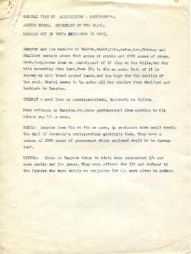
A General View of Agriculture in Oxfordshire
Map of Aston & Bampton dated 1773 pre Inclosure Act
Ordnance Survey Plan SP3002-3102 1971.    Cowleaze Corner  Weald to Aston Road
Ordnance Survey Plan SP3002-3102 1971. Cowleaze Corner Weald to Aston Road