Sales brochure for the outlying portions of Lew Estate Sept 27th 1917
- BCA - 2021.3138
- Item
- 1917
Sales brochure for the outlying portions of Lew Estate Sept 27th 1917
Nik Stanbridge
205 results with digital objects Show results with digital objects
Sales brochure for the outlying portions of Lew Estate Sept 27th 1917
Sales brochure for the outlying portions of Lew Estate Sept 27th 1917
Nik Stanbridge
Sales brochure for the Lew House Estate 2019
Lew House and the attached estate was put on the market in 2019. It could all be sold as one item or lots of land could be purchased separately. This Knight Frank sales brochure gives all the details.
Bampton Community Archive

Sales brochure for Lower Haddon Farm March 11th 1949
Sales brochure for Lower Haddon Farm March 11th 1949
Nik Stanbridge
Sales brochure for Ham Court 2010
Ham Court along with the barns and outbuildings plus 22 acres was put up for sale by Jesus College Oxford in 2010 and was bought by Emma Bridgewater. This is the sales brochure and I'm sorry to say the scanned versions given to me clearly had something wrong with the colour but the text is perfect. The diagrams of the first and second floor are very interesting. See also entry 2017.529
Nik Stanbridge
Sales brochure for Calais farm January 15th 1959
Sales brochure for Calais farm January 15th 1959
Nik Stanbridge
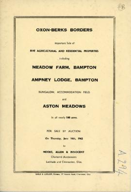
Sale brochure: Meadow farm; Ampney Lodge; Bungalow; Pasture field; Aston Meadows. June 14th 1962
Sale brochure: Meadow farm; Ampney Lodge; Bungalow; Pasture field; Aston Meadows. June 14th 1962
Nik Stanbridge
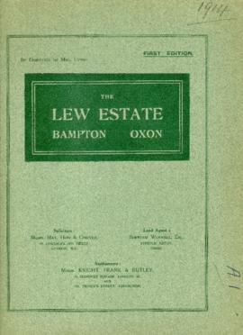
Sale brochure for The Lew Estate at 1914 by direction of Mrs Upton
Sale brochure for The Lew Estate at 1914 by direction of Mrs Upton
Nik Stanbridge
Report on the Survey & Plan of Bampton by M W Robinson, County Planning Officer October 1966
This report on the Survey & Plan of Bampton was done under the guidance of M W Robinson FRICS MTPI in October 1966. It makes very interesting reading and the conclusions are as relevant today as they were then. The topics covered are 1. Population 2. Situation 3. Character 4. The people 5. Shopping 6. Principal road connections 7. Schools 8. Open spaces 9. Social facilities, Public Services etc 10. Surface water drainage 11. Sewage disposal 12. Water supply and much more. It makes a very interesting read particularly in the light of all the dwellings that have been built here since October 1966, all those being built now (Jan 2017) and those being proposed when considering the access into Bampton has not been improved yet in 1966 one of the conclusions states was that Bampton could not take further development, a by-pass was not possible and no further space for parking other than possibly in Church Street could be made. Houses have since been built on the land in Church Street
Nik Stanbridge
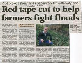
Red Tape cut to help Farmers Fight Floods
Newspaper article about red Tape which stands between landowners and Environment Agency.
Waterway Maintenance work to tackle flooding on land in west Oxfordshire
Janet Westman

Pre Inclosure map of Clanfield, Bampton, Aston & Yelford
The map is pre Inclosure and covers Clanfield, Bampton, Aston and Yelford. The note with the Yelford map says it was from a map of 1624/5. A note at the right side of the page suggests all these details were pulled together from various sources in 1833 which is post Inclosure, which for the Bampton area was 1821. I can't work out what maps were used for the non-Yelford map but it says HHH is Aston 1771.
Bampton Community Archive