- BCA - 2023.6820
- Item
- 1900
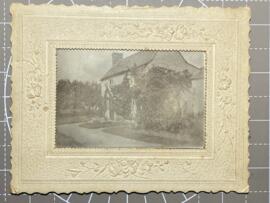
Mounted photograph of Sandford Cottage dated on the back to November 1900.
Donated to the Archive by Kirsten Hardie who's letter is included here.
Nik Stanbridge
1600 results with digital objects Show results with digital objects
Mounted photograph of Sandford Cottage dated on the back to November 1900.
Donated to the Archive by Kirsten Hardie who's letter is included here.
Nik Stanbridge
Bampton Morris Dancers - A Chronology
A Chronology of Performance in Bampton. itemising the events and names of the various dancers from 1790 through to the 1900's
Janet Westman
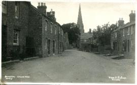
Church View (early C20th) looking to St Mary's
Church View looking to St Mary's
Nik Stanbridge
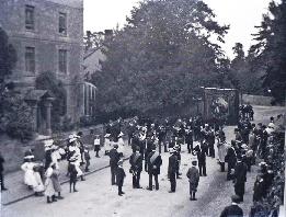
'Go Thou and Do Likewise' is on the top of the banner of the Friendly Society. On Hospital Sunday the members walked from their headquarters in one of the inns to St Mary's for a service and in this picture, they are seen leaving after the annual service. Before the days of the National Health Service, those who could, paid into 'the club' ie the Friendly Society and if they were ill and could not work, sufficient money was provided for the family to buy food. It was literally a life saver for them. The National Health Service came into being July 5th 1948.
1a Foresters A photograph of the Foresters with their banner outside Oathurst, now called Rosebank Nursing Home. Bampton’s Brass band is with them. People paid into clubs like the Foresters then, if they were unable to work, the club kept them from starving. This was before the welfare state came into being and so these friendly societies were very important.
Janet Westman

2nd edition maps of 1899 Bampton, Black Bourton, Mt Owen Road
These three maps are all labelled as 2nd edition 1899. They cover the area Central Bampton, north & south, east nearly to Aston, Black Bourton south to Cowleaze Corner, east to Elephant & Castle in Bridge Street and Mt Owen Rd, west to road going up to Lew now called Station Road.
They not only show the buildings but someone has written on in pencil when certain plots were sold and to whom.
Interesting to see the clear fish-farming area with the Deanery then called Deanery Farm, Cobb House simply called Vicarage, Churchgate House called Trinity Vicarage. The third vicarage is today called Kilmore House and is almost opposite the East window of St. Mary's.
What today is called Bridge Street was then called Mill Street and the mill was just to the left of path to Sandford Field from Bridge St. The legend is the mill wheel was buried in the plot to the left of the brook walking to the field from Bridge St and the tree there today was planted at its centre.
Bampton Community Archive

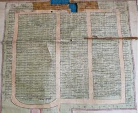
Second Edition 1899. Ordnance Survey Map Central Bampton east towards Aston
First of three Second Edition 1899 Ordnance Survey Maps showing Central Bampton, north & south, east nearly to Aston, Someone has annotated the map with pencil showing who owns various fields, and when bought and the cost.
Names of people owning fields
Mr. Wilkins
JG Andrews Trustees
FF Southby
Stevens of Calais Farm
WW Shepherd
Mr Rose
Mr Carter
Sold 18th May 1950 L H Saunders for £400
Sold 18th May 1950 Mr Read for £700
L Dafter
Sold 18th May 1950 to F A Gerring for £2275
Places shown on Map in 1899 as follows:
Beam Cottage
Bridge Street
Calais Farm
Cheapside
Church Street
Fishers Bridge
Manor Cottage
Manor House
New Inn Lane
Primrose Cottages
Swan Inn
The Grange
Janet Westman

Second Edition 1899 Ordnance Survey Map Mt Owen Rd, west towards Lew
Third of 3 Second Edition 1899 Ordnance Survey Maps Showing Mount Owen Road towards Lew. There are some pencil notes and some fields are coloured yellow.
The following places are shown
Lew Lodge
Coalpit Farm
Mount Owen Farm
Ditcham Wood
Rushey Butts
Janet Westman

Second Edition 1899. Ordnance Survey Map Black Bourton, Cowleaze Corner east to Central Bampton
Second of three Second Edition 1899 Ordnance Survey Maps showing Black Bourton, Cowleaze Corner to Central Bampton
and shows the following places
Manor House
Mill Bridge
Millgreen Terrace
New Inn Lane
Plantation
Sandford Villa
Swan Inn
The Grange
Trinity Vicarage
Weald Manor House
Janet Westman
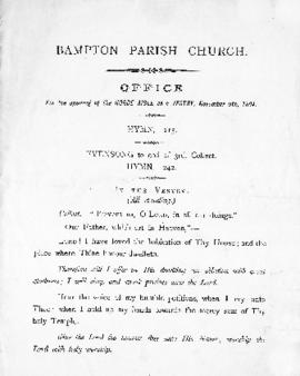
St. Mary the Virgin Church - Opening of the Horde Aisle as a vestry 1894
Printed Sheet with Hymns and Prayers for Order of Service - Opening of the Horde Aisle as a vestry Nov. 8th 1894
Attended by the Bishop
Janet Westman