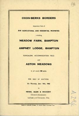
Sale brochure: Meadow farm; Ampney Lodge; Bungalow; Pasture field; Aston Meadows. June 14th 1962
- BCA - 2021.3136
- Item
- 1962
Sale brochure: Meadow farm; Ampney Lodge; Bungalow; Pasture field; Aston Meadows. June 14th 1962
Nik Stanbridge
69 results with digital objects Show results with digital objects
Sale brochure: Meadow farm; Ampney Lodge; Bungalow; Pasture field; Aston Meadows. June 14th 1962
Sale brochure: Meadow farm; Ampney Lodge; Bungalow; Pasture field; Aston Meadows. June 14th 1962
Nik Stanbridge
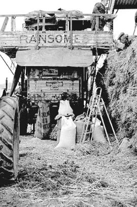
Colin Rouse experiments with old-style thrashing at Hobbs buildings
Colin Rouse experiments with old-style thrashing at Hobbs buildings with a Ransomes thresher, 1985
Nik Stanbridge
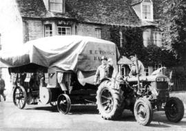
Harry Pocock with his thrashing machine and tractor in 1958
Harry Pocock with his thrashing machine and tractor in 1958 driving out of Church Street into Broad Street. Edwin, Ruth and Joe Buckingham are on the tractor with him.
An invoice from Harry Pocock & Son, Agricultural and Thrashing Contractor to Alex Townsend of Ashtree Farm (in Weald Street) for threshing and baling @ £47 5s (£47.25p) but with a contra account of 2ctw of tater (potatoes), 2 men combing and 5 gallons of paraffin £8.11s.6d (£8.55½p) giving a bill of £38.13s.6d (£38.65½p) sent April 1959.
An invoice from Harry Pocock & Son, Agricultural and Thrashing Contractor to Alex Townsend of Ashtree Farm (Weald Street) for threshing and baling sent December 1959.
Seen in the spring of 1963, talking with Marjorie Pollard in Cheapside, when we had huge drifts of snow.
Nik Stanbridge
Views of Backhouse Farm from No.3 Saint Mary's Trailer Court
Views of Backhouse Farm from No.3 Saint Mary's Trailer Court
Nik Stanbridge
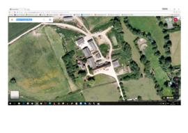
Aerial view of Ham Court before Emma Bridgwater alterations
Aerial view of Ham Court before Emma Bridgwater alterations
Nik Stanbridge

Pre Inclosure map of Clanfield, Bampton, Aston & Yelford
The map is pre Inclosure and covers Clanfield, Bampton, Aston and Yelford. The note with the Yelford map says it was from a map of 1624/5. A note at the right side of the page suggests all these details were pulled together from various sources in 1833 which is post Inclosure, which for the Bampton area was 1821. I can't work out what maps were used for the non-Yelford map but it says HHH is Aston 1771.
Bampton Community Archive

Map of Weald from Plantation south to Cowleaze Corner, east to the Elephant & Castle
This map of 1921 covers the area from Plantation south to Cowleaze Corner and east as far as the Elephant and Castle.
What was a watercourse off the Highmoor Brook to land with The Deanery can be clearly seen and was used for fish farming.
Cobb House is the only vicarage by now, the other two houses of the three-portion being in private hands, one Churchgate house the other now called Kilmore House.
Glebelands houses were not yet built, they didn't come until the 1960s.
The lake with Weald Manor House to its left used to freeze over and the owners of the Manor House used to invite locals to skate on it. Mr & Mrs Colvile lent the field to the west of the lake to the local football club but as it wasn't large enough for the side to play in a certain league, they had to find a new home and for a while used a field at the east end of New Road.
Bampton Community Archive

Map with the sale of 5 residential and agricultural properties 1962
This map was produce by Morre, Allan and Innocent to accompany the sale for 5 residential and agricultural properties May 14th 1962. They are all east and south east of Bampton's main residential area.
Lot 1 is Meadow Farm
Lot 2 is to the north of the Aston road and include Ampney Lodge
Lot 3 is a strip with Calais farm
Lot 4 is a field approximately where Bampton Garden Centre is today
Love 5 is a group of fields to the south of the Great Brook
Bampton Community Archive

These four maps were all produce in 1971 and cover
Ordinance Survey Plan SP3002-3102 Weald, Hayway Lane, Weald St, Clanfield Road
Ordinance Survey Plan SP3003-3103. Bridge St east to end of houses, north to new school, Colvile Close
Ordinance Survey Plan SP3203-3303. 1971 Mt Owen Rd east inc. Gogg Lane, Aston Rod to Aston
Ordinance Survey Plan SP3002-3102 1971. Cowleaze Corner, Weald to Aston, north to Horse Shoe PH
Fields, property and farms are all clearly marked.
Bampton Community Archive