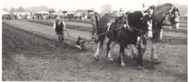
1983 FFF&B Ploughing Match held at Weald Farm
- BCA - 2021.3159
- Item
- 2021
1983 FFF&B Ploughing Match held at Weald Farm
Nik Stanbridge
1983 FFF&B Ploughing Match held at Weald Farm
1983 FFF&B Ploughing Match held at Weald Farm
Nik Stanbridge
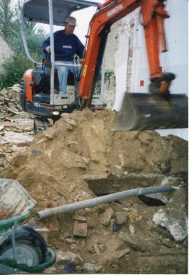
Well, now re-covered and inside the kitchen at Castle View (farmhouse)
Well, now re-covered and inside the kitchen at Castle View (farmhouse)
Nik Stanbridge

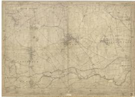
Second Edition 1899. Ordnance Survey Map Black Bourton, Cowleaze Corner east to Central Bampton
Second of three Second Edition 1899 Ordnance Survey Maps showing Black Bourton, Cowleaze Corner to Central Bampton
and shows the following places
Manor House
Mill Bridge
Millgreen Terrace
New Inn Lane
Plantation
Sandford Villa
Swan Inn
The Grange
Trinity Vicarage
Weald Manor House
Janet Westman

Map of 1797. Westwell east to Curbridge, Kemscott east to Coat Common plus St Giles Oxford
This map of 1797 shows the Bampton Hundred and the fields. There is also a map of St Giles in Oxford at this time. Today, Kelmscott is spelt with two Ts but on this map it has one.
Bampton Community Archive

1913 map of Weald, west to Marsh Lane on east edge of Clanfield
This map is from 1913 and covers the area from Marsh Lane on the eastern edge of Clanfield west across Weald. However, all of Bridge Street, half the Talbot Inn, the west side of the Market Square, the South side of Church Street and Church View are all in Weald and they are not shown here, possibly because the map was for agricultural purposes. There are some very interesting notes added in pencil.
Bampton Community Archive

This map shows the Bampton Estates at 1789. This is before the fields were enclosed and the names of the people who farmed the strips or the name of the field area are on the map. The Quies fields are each side of the Bampton to Brize Norton road, just north of what is now Hobbs Buildings.
The Clanfield to Bampton road is showing top to bottom on the map whereas it really runs east west, so you need to get your head around that, literally.
What we now call Welcome Way is called Wiltham Way - it runs south from Cowleaze Corner into Weald.
Weald Common Meadow was south of what we now think of as the area containing the two Bampton Business Parks.
The Bampton to Buckland road is showing going left to right on the map when it actually runs NW to SE; it had a turnpike.
Bampton Community Archive
1922 map of Clanfield, Alvescot, Black Bourton, Grafton, Bampton, Aston, Cote & Chimney
This map was produced in 1922 and shows the field system as well as the parliamentary boundaries as at 1918.
There are many interesting notes written on in pencil. The water tower and gas works along the Aston Road were in existence. The allotment gardens NW of Beam Cottage are labelled as is the gravel pit to the SW of Beam Cottage.
There are no houses to the north of New Road and none to the south of it going east from Bushey Row.
Rushy Weir is shown clearly as is the tow path to the south side of the river Thames.
Bampton Community Archive
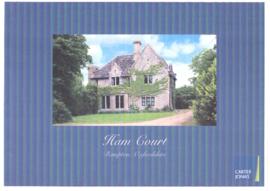
Sales brochure for Ham Court 2010
Ham Court along with the barns and outbuildings plus 22 acres was put up for sale by Jesus College Oxford in 2010 and was bought by Emma Bridgewater. This is the sales brochure and I'm sorry to say the scanned versions given to me clearly had something wrong with the colour but the text is perfect. The diagrams of the first and second floor are very interesting. See also entry 2017.529
Nik Stanbridge
Report on the Survey & Plan of Bampton by M W Robinson, County Planning Officer October 1966
This report on the Survey & Plan of Bampton was done under the guidance of M W Robinson FRICS MTPI in October 1966. It makes very interesting reading and the conclusions are as relevant today as they were then. The topics covered are 1. Population 2. Situation 3. Character 4. The people 5. Shopping 6. Principal road connections 7. Schools 8. Open spaces 9. Social facilities, Public Services etc 10. Surface water drainage 11. Sewage disposal 12. Water supply and much more. It makes a very interesting read particularly in the light of all the dwellings that have been built here since October 1966, all those being built now (Jan 2017) and those being proposed when considering the access into Bampton has not been improved yet in 1966 one of the conclusions states was that Bampton could not take further development, a by-pass was not possible and no further space for parking other than possibly in Church Street could be made. Houses have since been built on the land in Church Street
Nik Stanbridge