Showing 103 results

Archival description
Item Bampton General Text With digital objects
Print preview View:

Ploughing Match FFF&B 1980

  • BCA - 2022.3965
  • Item
  • 1988

Series of Photographs taken early 1980 featuring some of the machinery on display. The photos are described as follows:
BA40FA~1 - Ploughing with teams of 3 bullocks, young boy leading the front bullock and a ploughman on the reins. Each team pulled a single furrow plough.
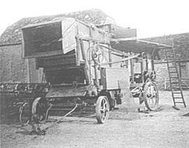
BA2357~1 - Mr Fred Hornsby at the front of the combine. Fred worked for John Henly on Bampton Deanery farm and in later years for his son Roy. This picture approximately 1980.
BA0C0D~1 - Detail of a traction engine. There would have been one at opposite sides of the field and the implement, such as a plough or potato drill, would be pulled from side to side by the steel hawser seen here under the engine. The engine provided the power to turn the cable drum to wind in the cable. Originally the engine would have been fired by solid fuel but many were later converted to run on oil.
BABDA1~1 - Douglas Read, OBE born 1926 taking part in a ploughing match. Doug got his MBE several years after this picture was taken and it was for services to ploughing. He has was national ploughing match champion more than once and in later years was a judge for the High Cut class at the Fairford, Faringdon, Filkins and Burford Ploughing Match. (Known to many locals as the 3Fs and a B).
BA4883~1 - The driver of a plough being drawn across the field by a traction engine at the Fairford, Faringdon, Filkins and Burford Ploughing match.

Janet Westman

Playing Field in New Road 1988

  • BCA - 2022.3804
  • Item
  • 1988

Image of young girl on seesaw in the Playing Field. New Road.
View shows houses in Bushey Row.
Adjacent to Fire Station, Field has been built over with Pembroke Close

Janet Westman

Ordnance Survey PlanSP3002-3102 Weald, Hayway Lane, Weald St, Clanfield Rd. 1971

  • BCA - 2022.3824
  • Item
  • 1971

Ordnance Survey PlanSP3002-3102
extending from Weald, Hayway Lane, Weald St, Clanfield Rd. dated 1972 and showing the following properties and places:
Ashtree
Aulnoy
Backhouse Farm
Bournemead
Brook Farm
Brook Hoiuse
Buckland Road
Caravan Park
Cheyne Lane
Clanfield Road
College Farm House
Corner Farm
Cowleaze Corner
Dunlaoghaire
Fisher's Bridge
Gate Cottage
Glebe Farm
Ham Court
Ham Court Cottages
Highmoor House
Knapps Farm
Lime Tree Cottages
Mill Bridge
Mill Green
Orchard Cottage
Rose Cottage
Shill Brook
Shrangri-la
Spring Cottages
St Frideswide
Stable Cottage
Sunnyside
Thatch Cottage
The Old Farmhouse
Weald Farm
Weald Manor Cottage
Weald Manor
Weald Manor Farm

Janet Westman

Ordnance Survey Plan SP3203-3303. 1971 Mt Owen Rd east inc. Gogg Lane, Aston Road to Aston

  • BCA - 2022.3826
  • Item
  • 1971

Ordnance Survey Plan SP3203-3303. 1971 Extending from Mt Owen Rd east inc. Gogg Lane, Aston Road and part of Aston. showing the following places:
New Road
White Owl Farm
Bradshaw Close
Kenlincott
Kiln Close
Back Lane
Greenacres Lane
Elmside
Barry House
Ferndale
Back Cottage

Byeways
Laundry Lane
Kingsway Farm
High Street West End
The Limes
West End Farm
Home Farm House
Greens Row
Elvina
Aston Ditch
Mercury Close
Beam Cottage
Old Gasworks Building
New Road
The Willows
St Andrews

Janet Westman

Ordnance Survey Map dated 1922 Grafton to Chimney including villages

  • BCA - 2022.3830
  • Item
  • 1922

Ordnance Survey Map Dated 1922. showing villages from Grafton Clanfield, Alvescot, Bampton south to Thames, Aston, Chimney
There are pencil notes on the map difficult to read'
The places printed on map are as follows
Bampton
Baptist Chapel
Beam Cottage
Bridge Street
Broad Street
Broad Street
Calais Farm
Castle remains
Cheapside
Church Lane
Churchgate House
Coalpit Farm
Deanery Farm
Elephant and Castle
Fishers Bridge
Gas Works
Ham Court
Highmoor Brook
Lady Well
Manor Cottage
Manor House
Mill Barn
Mill Bridge
Mount Owen Farm
New Inn Lane
Old Gravel Pit
Plantation
Primrose Cottages
Sandford Villa
Swan Inn
The Grange
Vicarage
Water Tower
Weald Manor House
Windmill House
Wrights hill
Lower Haddon Farm
Ven Bridge
Elmwood House

Alvescot
Alvescot House
Alvescot Lodge
Alvescot Mill
Alvescot Station
Bates Land Farm
Buxhill Farm
Manor Farm Alvescot
Milestone Road
Old Chapel Pit
Plough Inn
Rectory Farm
Red Lion PH
Royal George PH
Shield Farm
Smithy
St Peters Church
The Rectory
Vine Cottage

Clanfield
Little Clanfield
Grafton Green Farm
Little Clanfield Mill
Manor Farm

Radcot
Radcot New Buildings
Langley Lane
Langford Brook
Ashton Pill Bridge
Swan Inn
Cradle Bridge (Foot)
Radcot Bridge
River Thames
Entrenchment The Garrison
Towing Path
Radcot Lock
Sharney Brook
Burroway Brook
Burroway Bridge
Sharney Bridge
River Thames or Isis
Old Mans Bridge

Clanfield
Manor Farm
Broadwell Brook
Chestlion Farm
Clanfield Weir Farm
Engineering Work
Friar's Court Monastry
Pound Lane
St Stephens
Windmill Farm

Black Bourton
East Gloucestershire Branch Railway
Garsons Copse
High House
Manor Farm
Moat House
St Marys Church
Vicarage
Corn Mill
Lower Farm

Buckland Road
Boat House
Buckland Marsh
Great Brook
Isle of Wight Bridge
Meadow Farm
Tadpole Bridge
Tenfoot Bridge

Aston, Cote and Chimney
Aston House
Bull Inn
Bull Street
Cote House
Cote Lodge
Duckend Farm
Girls Training Home
Ham Lane
Kingsway Farm
North Street
Old Clay Pit
St James Church

Yelford
Claywell Farm
Elmbank
Manor Farm
Newhouse Farm
Rickless Hill
St Swithins Church
Yelford Manor
Ditcham Wood
Rushey Butts
Lew Lodge

Janet Westman

Morris Dancing Platinum Jubilee 2022

  • BCA - 2022.3959
  • Item
  • 2022

Copy of the programme for the Morris Dancers Bank Holiday Queen Elizabeth II 70th Jubilee celebrations.

Janet Westman

Methodist Church Outing

  • BCA - 2022.3867
  • Item
  • 1940's

Photograph showing a party of Methodist members going on an outing standing in front of bus.
Names have been added to the second copy as follows
Eva Mary Portlock
Mrs Portlock
Dora Townsend
Mrs Townsend
Ted Kitchen
Mrs Smith and Son
Polly
Aggie Beckett
Mrs Bishop
Cecil Robinson
Bert Whitlock

Janet Westman

Maps of East Half of Bampton 1921

  • BCA - 2022.3814
  • Item
  • 1921

3 Large ordnance Survey Maps used by Hadgood and Mammatt Auctioneers and Estate Agents from Witney. Published in 1921 price £5/- and £6/8d. Points of interest are Highmoor Brook, Plantation, Ham Court, Deanery Farm, Churchgate, Vicarage, Manor House, and Weald Manor House, old gravel pit and Beam Cottage, Calais Farm, Primrose Cottages, Fisher's Bridge

Janet Westman

Map of Bampton Estate at 1789

  • BCA - 2019.1890
  • Item
  • 1789

This map shows the Bampton Estates at 1789. This is before the fields were enclosed and the names of the people who farmed the strips or the name of the field area are on the map. The Quies fields are each side of the Bampton to Brize Norton road, just north of what is now Hobbs Buildings.
The Clanfield to Bampton road is showing top to bottom on the map whereas it really runs east west, so you need to get your head around that, literally.
What we now call Welcome Way is called Wiltham Way - it runs south from Cowleaze Corner into Weald.
Weald Common Meadow was south of what we now think of as the area containing the two Bampton Business Parks.
The Bampton to Buckland road is showing going left to right on the map when it actually runs NW to SE; it had a turnpike.

Bampton Community Archive

Results 41 to 50 of 103