
- BCA - 2022.3833
- Item
- 1914
Plan of the Lew Estate, Oxfordshire divided into coloured sections/Lots for sale by auction by Messrs Knight, Frank and Rutley .
Sem título
15 resultados diretamente relacionados Excluir termos específicos
Plan of the Lew Estate, Oxfordshire divided into coloured sections/Lots for sale by auction by Messrs Knight, Frank and Rutley .
Sem título

Second Edition 1899 Ordnance Survey Map Mt Owen Rd, west towards Lew
Third of 3 Second Edition 1899 Ordnance Survey Maps Showing Mount Owen Road towards Lew. There are some pencil notes and some fields are coloured yellow.
The following places are shown
Lew Lodge
Coalpit Farm
Mount Owen Farm
Ditcham Wood
Rushey Butts
Sem título

Second Edition 1899. Ordnance Survey Map Black Bourton, Cowleaze Corner east to Central Bampton
Second of three Second Edition 1899 Ordnance Survey Maps showing Black Bourton, Cowleaze Corner to Central Bampton
and shows the following places
Manor House
Mill Bridge
Millgreen Terrace
New Inn Lane
Plantation
Sandford Villa
Swan Inn
The Grange
Trinity Vicarage
Weald Manor House
Sem título

Second Edition 1899. Ordnance Survey Map Central Bampton east towards Aston
First of three Second Edition 1899 Ordnance Survey Maps showing Central Bampton, north & south, east nearly to Aston, Someone has annotated the map with pencil showing who owns various fields, and when bought and the cost.
Names of people owning fields
Mr. Wilkins
JG Andrews Trustees
FF Southby
Stevens of Calais Farm
WW Shepherd
Mr Rose
Mr Carter
Sold 18th May 1950 L H Saunders for £400
Sold 18th May 1950 Mr Read for £700
L Dafter
Sold 18th May 1950 to F A Gerring for £2275
Places shown on Map in 1899 as follows:
Beam Cottage
Bridge Street
Calais Farm
Cheapside
Church Street
Fishers Bridge
Manor Cottage
Manor House
New Inn Lane
Primrose Cottages
Swan Inn
The Grange
Sem título

Ordnance Survey Map dated 1922 Grafton to Chimney including villages
Ordnance Survey Map Dated 1922. showing villages from Grafton Clanfield, Alvescot, Bampton south to Thames, Aston, Chimney
There are pencil notes on the map difficult to read'
The places printed on map are as follows
Bampton
Baptist Chapel
Beam Cottage
Bridge Street
Broad Street
Broad Street
Calais Farm
Castle remains
Cheapside
Church Lane
Churchgate House
Coalpit Farm
Deanery Farm
Elephant and Castle
Fishers Bridge
Gas Works
Ham Court
Highmoor Brook
Lady Well
Manor Cottage
Manor House
Mill Barn
Mill Bridge
Mount Owen Farm
New Inn Lane
Old Gravel Pit
Plantation
Primrose Cottages
Sandford Villa
Swan Inn
The Grange
Vicarage
Water Tower
Weald Manor House
Windmill House
Wrights hill
Lower Haddon Farm
Ven Bridge
Elmwood House
Alvescot
Alvescot House
Alvescot Lodge
Alvescot Mill
Alvescot Station
Bates Land Farm
Buxhill Farm
Manor Farm Alvescot
Milestone Road
Old Chapel Pit
Plough Inn
Rectory Farm
Red Lion PH
Royal George PH
Shield Farm
Smithy
St Peters Church
The Rectory
Vine Cottage
Clanfield
Little Clanfield
Grafton Green Farm
Little Clanfield Mill
Manor Farm
Radcot
Radcot New Buildings
Langley Lane
Langford Brook
Ashton Pill Bridge
Swan Inn
Cradle Bridge (Foot)
Radcot Bridge
River Thames
Entrenchment The Garrison
Towing Path
Radcot Lock
Sharney Brook
Burroway Brook
Burroway Bridge
Sharney Bridge
River Thames or Isis
Old Mans Bridge
Clanfield
Manor Farm
Broadwell Brook
Chestlion Farm
Clanfield Weir Farm
Engineering Work
Friar's Court Monastry
Pound Lane
St Stephens
Windmill Farm
Black Bourton
East Gloucestershire Branch Railway
Garsons Copse
High House
Manor Farm
Moat House
St Marys Church
Vicarage
Corn Mill
Lower Farm
Buckland Road
Boat House
Buckland Marsh
Great Brook
Isle of Wight Bridge
Meadow Farm
Tadpole Bridge
Tenfoot Bridge
Aston, Cote and Chimney
Aston House
Bull Inn
Bull Street
Cote House
Cote Lodge
Duckend Farm
Girls Training Home
Ham Lane
Kingsway Farm
North Street
Old Clay Pit
St James Church
Yelford
Claywell Farm
Elmbank
Manor Farm
Newhouse Farm
Rickless Hill
St Swithins Church
Yelford Manor
Ditcham Wood
Rushey Butts
Lew Lodge
Sem título

Ordnance Survey Plan SP3002-3102 1971. Cowleaze Corner Weald to Aston Road
Ordnance Survey Plan SP3002-3102 dated 1971. Cowleaze Corner, Weald to Aston, north to Horse Shoe
and showing the following places and buildings
Ashtree
Aulnoy
Backhouse Farm
Bournemead
Brook Farm
Brook House
Buckland Road
Caravan Park
Cheyne Lane
Clanfield Road
College Farm House
Corner Farm
Cowleaze Corner
Cricket Field
Dunlaoghaire
Fisher's Bridge
Gate Cottage
Glebe Cottage
Glebe Farm
Ham Court
Ham Court Cottages
Highmoor House
Knapps Farm
Lime Tree Cottages
Mill Bridge
Mill Green
Orchard Cottage
Primrose Cottages
Rose Cottage
Shill Brook
Shrangi-la
Spring Cottages
St Frideswide
Stable Cottage
Sunny view
Sunnyside
Thatch Cottage
The Bungalow
The Lodge
The Old Farmhouse
Weald Farm
Weald Farm Cottages
Weald Manor
Weald Manor Cottage
Weald Manor Farm
Sem título

Lower Haddon Farm 1949 Auction Maps
two maps - A Plan of Lower Hadden Farm from the Auction held in March 1949, and a hand drawn map of same area
Auctioneers were Jackson-Stops (Cirencester)
With hand written field names as follows
Bampton Station Fairford to Oxford GWR
Barnleys Pasture
Big Barleys
Big Row
Black Bourton Road
Bowlie Ground
Bridle Path to Black Bourton
Bridle Road
Broad Close
Cow Leas
Far Hill
Far Limber
Front Field
Furse Hill
Harps
Highmoor Brook
Home Close
Horn Ground
James' Meadow
Little Barleys
Long Meadow
Lower Hadden Farm
Middle Hill
Mill Barn Copse
Near Barleys
Near Limber
Pike Ground
Pond Gardens
Rogers Meadow
Rushey Row
Smart Hill
The Big Monk
Water Meadows
Willow Beds
Sem título
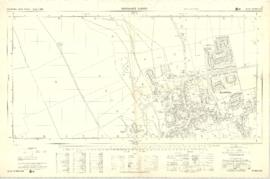
Ordnance Survey Plan SP3003-3103. Bridge St east Colvile Close etc 1971
This Ordnance Survey Plan SP3003-3103. Dated 1971 shows area
Bridge St east to end of houses, north to new school, Colvile Close etc
Properties and Streets listed :
Air Training Corps
Ampney Lodge
Apple Tree Cottage
April Cottage
Army cadet Hut
Bakery
Bampton House
Bay Tree Cottage
Belgrave Cottage
Blackthorn Cottage
Blackthorn Cottagre
Bourton Cottage
Box House
Bushey House
Calais Farm
Cheapside
Chestnuts
Churchgate House
Churchgate House
Clevelly
Cobb House
Corner Cottage
Cornmill
Cotsway
Cotswold Lodge
Courtlands
Dairy Farm House
Deanery Farm
Down Home
Elephant and Castle
Eton Villas
Felix Cottage
Fernlea
Field Cottage
Fishers Bridge
Fleur de Lys
Folly House
Folly View
Fox Close
George and Dragon
Grayshot House
Ham Court
Haytor House
Highmoor Brook
Inglenook Cottage
Kilmore House
Kilmore House
Landells
Leighton Cottage
Lester House
Library
Lime Tree House
Little Pinkneys
Little Place Cottage
Littlemead
Lynton Mead
Mallows
Manor House
Matthew House
Melita
Moss Rose Cottage
Oathurst Estate
Plantation
Pococks Close
Police Office
Poplar Cottage
Primrose Cottages
Priory Cottage
Prospect Cottage
Prospect House
Prospect Place
Quebec Cottage
Rhandom
Roseann
Rosebrook
Rosemary House
San Toy
Sandford House
Southrop House
Southside
St Johns House
St Oswald
Sunnyside Cottage
Thatched Cottage
The Bungalow
The Deanery
The Eagle
The Elms
The Gate Cottage
The Glen
The Grange
The Grey House
The Haven
The Hermitage
The Horse Shoe
The Jubilee
The Malt Shovel
The Old Forge
The Vicarage
The Yews
Town Hall
Tudor Cottage
Turnings
Vaizey Cottage
Vicarage
Victoria Cottages
Vine Cottage
Weald Manor House
Wheelgate House
Windsmore
Windsor Cottagres
Yew Tree Cottage
Youth Club
Ampney Orchard
Aston Road
Bowling Green Close
Bridge Street
Broad Street
Buckland Road
Bushey Row
Chandler Close
Cheapside
Church Lane
Church Street
Church View
Colvile Close
Glebelands
High Street
High Street
Lavender Square
Manor View
Mercury Close
New Road
Queens Street
Rosemary Lane
Sem título

Ordnance Survey PlanSP3002-3102 Weald, Hayway Lane, Weald St, Clanfield Rd. 1971
Ordnance Survey PlanSP3002-3102
extending from Weald, Hayway Lane, Weald St, Clanfield Rd. dated 1972 and showing the following properties and places:
Ashtree
Aulnoy
Backhouse Farm
Bournemead
Brook Farm
Brook Hoiuse
Buckland Road
Caravan Park
Cheyne Lane
Clanfield Road
College Farm House
Corner Farm
Cowleaze Corner
Dunlaoghaire
Fisher's Bridge
Gate Cottage
Glebe Farm
Ham Court
Ham Court Cottages
Highmoor House
Knapps Farm
Lime Tree Cottages
Mill Bridge
Mill Green
Orchard Cottage
Rose Cottage
Shill Brook
Shrangri-la
Spring Cottages
St Frideswide
Stable Cottage
Sunnyside
Thatch Cottage
The Old Farmhouse
Weald Farm
Weald Manor Cottage
Weald Manor
Weald Manor Farm
Sem título

1797 Map showing Bampton Hundred
Map showing Oxfordshire area from Westwell to Curbridge and Kelmscot to Coat (Cote) Common, Bampton Hundred,
plus segment showing St Giles, Oxford.
Published by R. Davis Lewknor August 1797 and indicating:
Alvescot, Asthrop Farm, Aston, Bampton and Aston Fields, Bampton in the Bush, Barley Park, Black Bourton, Brize Norton, Broadwell Grove, Broughton, Burwell Farm, Caswell, Clanfield, Clarks Wier, Claywell, Coat, Curbridge, David Wier, Ducklington, Ducklington, Eaton Hastings, Eaton Hastings, Friars Court, Grafton, Great Lemhill, Harts Wier, Holwell, Kelmscot, Kencote, Langfiord, Lew Barrow, Lew Barrow, Little Clanfield, March Haddon, Nans Wier, Nethber Filkins, New Mill, Ouseham Mill, Over Filkins, Oxley, Radcot, Rushey , Shill Farm, Shilton, Signet, Starvehall Farm, Sworn Leys, Tadpole and Bridge, Ten Foot Wier, Turnpike, Westwell, Witney Park, ,
Sem título