Showing 3881 results

Archival description
Print preview View:

3825 results with digital objects Show results with digital objects

Ordnance Survey Plan SP3003-3103. Bridge St east Colvile Close etc 1971
Ordnance Survey Plan SP3203-3303. 1971 Mt Owen Rd east inc. Gogg Lane, Aston Road to Aston
Lower Haddon Farm 1949 Auction Maps
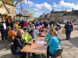
Sale for Ukrainian refugees
Ordnance Survey Plan SP3002-3102 1971.    Cowleaze Corner  Weald to Aston Road
Ordnance Survey Plan SP3002-3102 1971. Cowleaze Corner Weald to Aston Road
Ordnance Survey Map dated  1922 Grafton to Chimney including villages
Ordnance Survey Map dated 1922 Grafton to Chimney including villages
Second Edition 1899. Ordnance Survey Map Central Bampton east  towards Aston
Second Edition 1899. Ordnance Survey Map Central Bampton east towards Aston
Second Edition 1899 Ordnance Survey Map Mt Owen Rd, west towards Lew
Second Edition 1899. Ordnance Survey Map Black Bourton, Cowleaze Corner east to Central Bampton
The Lew Estate 1914
The Lew Estate 1914
Results 1391 to 1400 of 3881