The Beam was produced 3 and sometimes 4 times a year. This edition from April 1992 included the following topics and advertisers.
A decade of change in Bampton: An appraisal Low Cost Homes latest Annual Shirt Race The Deanery: Restoration & Exploration Lime Trees in Broad Street Parish News Speeding Traffic Traffic Calming Parish Council Minutes McKenie Brown - Electrical Plumbing Bampton Fax Bureau Stephen Hailes - Plumbing MH Thomas - Building, Landscape Gardening and Fencing Contractor Home Made Labrador - Printing R Boland & Sons - Fresh fruit & vegetables J Temple - Hardware, DIY, Fancy Goods and Toys Bampton Driving School The Bush Club: Plans for the future Easter Services A New Sunday School Wanted: Singers for Church Choir The Gardening Column CBL Electric Vehicles Ltd Bampton Village Hall Bampton Youth Centre Bampton Environmental Watch Group Bampton WI The MS Society The Bampton Bush Club Bampton Swimming Pool Appeal Bampton Brownies Low Cost Housing Supplement: From Appraisal to Action Ridge & Partners - Chartered Surveyors Coleman Hicks Partnership - Architects Fisher & Townsend (Contractors) Ltd - Building Contractors New Playground Site map of Bampton Site plan for low-cost housing scheme Hedge Your Bets - Environment Appraisal Questionnaire Oxford College of Further Education Bampton Horticultural Society The Royal British Legion Poppy Appeal Bampton Pumpkin Club Bampton Wives Club SPAJERS Bampton Pre-school Playgroup Bampton Drama Group Arts - West Oxfordshire Arts Association Charles McCord Mussett Junior Beam Crossword R Cooper - Builders The Talbot Hotel Curtain Choice Andrew Bowman - Thatcher Health Matters - Welbeing J Godfrey & Son - Funeral Directors Martin Drew - Chiropodist Medical Matters Oxfordshire Community Care Plan 1992/93 Painless Surgical Operations at Bampton Centre for Complementary Medicine Happy Memories - Girl Guides A Fisket-a-Tasket - Flower Design A Simmonds - Baker E Taylor - Funeral Directors Grey Gables Garage N Woodley Building Maintenance Witney Grass Cutting John King - Heating Engineer The Romany Inn Bampton Directory
The Beam publication was produce 3 and sometimes 4 times a year. This edition from December 1992 contains the following articles and advertisers. Homelessness Bampton Schools The Library Letters McKenzie & Brown - Plumbing & Electrical Bampton Fax Bureau Stephen Hailes Plumbing MH Thomas - Building, Landscape Gardening and Fencing Contractor Bubbles - Dog Grooming Paul van Aardt - Chiropodist J Temple - Hardware, DIY, Fancy Goods and Toys Bampton Driving School The Misses Pombroy’s Establishment for Young Ladies CBL Electric Vehicles Ltd Bampton Badminton Club Mother’s Union Cancer Relief Macmillan Fund The MS Society The Pumpkin Club SPAJERS National Blood Transfusion Service Royal British Legion Bampton Boys Football Club Traffic Speed Constable Steve Patrick - Community Policeman Prize Crossword R Coopers - Builder The Talbot Hotel Curtain Choice Andrew Bowman Health Matters J Godfrey & Son - Funeral Directors Martin Drew - Chiropodist Windfall Apples The West Oxfordshire Observer Land Adjoining the Bampton Youth Centre A Simmonds - Baker E Taylor - Funeral Directors Grey Gables Garage N Woodley Building Maintenance A Fisket-a-Tasket - Flower Designs John King - Plumber Diary of events The Romany Inn
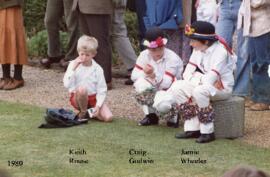
These are the young dancers in Francis Shergold's side 1980, the Bampton Traditional Morris Men. They include Keith Rouse, Jamie Wheeler and Craig Godwin.
These four maps were all produce in 1971 and cover
Ordinance Survey Plan SP3002-3102 Weald, Hayway Lane, Weald St, Clanfield Road Ordinance Survey Plan SP3003-3103. Bridge St east to end of houses, north to new school, Colvile Close Ordinance Survey Plan SP3203-3303. 1971 Mt Owen Rd east inc. Gogg Lane, Aston Rod to Aston Ordinance Survey Plan SP3002-3102 1971. Cowleaze Corner, Weald to Aston, north to Horse Shoe PH
Fields, property and farms are all clearly marked.
The map was produced in 1921. The first map is has been reused to show where council houses were to be built on the south side of New Road and where the sewerage pipes were to be laid to the sewerage works along the Buckland Road.
Mains sewerage came to Bampton in 1958 after a long struggle and at a cost of £105,000. Miss Marjorie Pollard was the driving force but in the end, it was the death of Horace Morse who emptied the 'night soil' buckets twice a week which made it imperative. Jack Bellinger was the first manager of the sewerage works.
These three maps are all labelled as 2nd edition 1899. They cover the area Central Bampton, north & south, east nearly to Aston, Black Bourton south to Cowleaze Corner, east to Elephant & Castle in Bridge Street and Mt Owen Rd, west to road going up to Lew now called Station Road. They not only show the buildings but someone has written on in pencil when certain plots were sold and to whom. Interesting to see the clear fish-farming area with the Deanery then called Deanery Farm, Cobb House simply called Vicarage, Churchgate House called Trinity Vicarage. The third vicarage is today called Kilmore House and is almost opposite the East window of St. Mary's. What today is called Bridge Street was then called Mill Street and the mill was just to the left of path to Sandford Field from Bridge St. The legend is the mill wheel was buried in the plot to the left of the brook walking to the field from Bridge St and the tree there today was planted at its centre.
This map shows the Bampton Estates at 1789. This is before the fields were enclosed and the names of the people who farmed the strips or the name of the field area are on the map. The Quies fields are each side of the Bampton to Brize Norton road, just north of what is now Hobbs Buildings. The Clanfield to Bampton road is showing top to bottom on the map whereas it really runs east west, so you need to get your head around that, literally. What we now call Welcome Way is called Wiltham Way - it runs south from Cowleaze Corner into Weald. Weald Common Meadow was south of what we now think of as the area containing the two Bampton Business Parks. The Bampton to Buckland road is showing going left to right on the map when it actually runs NW to SE; it had a turnpike.