These four maps were all produce in 1971 and cover
Ordinance Survey Plan SP3002-3102 Weald, Hayway Lane, Weald St, Clanfield Road Ordinance Survey Plan SP3003-3103. Bridge St east to end of houses, north to new school, Colvile Close Ordinance Survey Plan SP3203-3303. 1971 Mt Owen Rd east inc. Gogg Lane, Aston Rod to Aston Ordinance Survey Plan SP3002-3102 1971. Cowleaze Corner, Weald to Aston, north to Horse Shoe PH
Fields, property and farms are all clearly marked.
These are two parts of one map created in 1914. I've picked them out to show where the school used to be in Lew, next to University Farm and the Post Office a little to the east just before you get to Trinity Church.
This map was produce for the sale of the Lew Estate in 1914. There used to be a Post Office and a school in Lew, both shown on this map between University Farm and Holy Trinity Church on the main road.
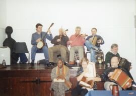
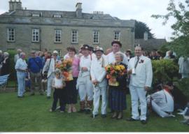
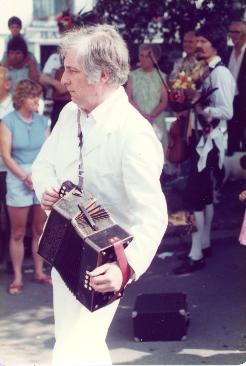
Francis Shergold's side, the Bampton Traditional Morris Men on Spring Bank Holiday. Craig Godwin and Jamie Wheeler got their tankards for 25 years of dancing with the side, presented at Weald Manor. This was the last year Rod Stradling was one of the musicians with the side.
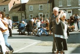
The Bampton Traditional Morris Men, squire Francis Shergold, danced in Wadebridge on August Bank Holiday. Some of the people in the photographs include Reg Hall musician, Martin Ferguson, Ivy Poole, 'big' Eric Stott, Colin Bathe, Trig Morris Men, Rod Stradling, Francis Shergold, Jamie Wheeler, Jim Buckingham, Dave Rose, Ted Poole, Roy Shergold.
These pictures were taken by Bob West during the May Bank holiday weekend 1997. People in the pictures include Ann and Francis Shergold, Reg Hall, Craig Godwin, Jamie Blackwell and other members of the Francis Shergold side.
The Beam publication was produce 3 and sometimes 4 times a year. This edition from December 1992 contains the following articles and advertisers. Homelessness Bampton Schools The Library Letters McKenzie & Brown - Plumbing & Electrical Bampton Fax Bureau Stephen Hailes Plumbing MH Thomas - Building, Landscape Gardening and Fencing Contractor Bubbles - Dog Grooming Paul van Aardt - Chiropodist J Temple - Hardware, DIY, Fancy Goods and Toys Bampton Driving School The Misses Pombroy’s Establishment for Young Ladies CBL Electric Vehicles Ltd Bampton Badminton Club Mother’s Union Cancer Relief Macmillan Fund The MS Society The Pumpkin Club SPAJERS National Blood Transfusion Service Royal British Legion Bampton Boys Football Club Traffic Speed Constable Steve Patrick - Community Policeman Prize Crossword R Coopers - Builder The Talbot Hotel Curtain Choice Andrew Bowman Health Matters J Godfrey & Son - Funeral Directors Martin Drew - Chiropodist Windfall Apples The West Oxfordshire Observer Land Adjoining the Bampton Youth Centre A Simmonds - Baker E Taylor - Funeral Directors Grey Gables Garage N Woodley Building Maintenance A Fisket-a-Tasket - Flower Designs John King - Plumber Diary of events The Romany Inn
This map of 1797 shows the Bampton Hundred and the fields. There is also a map of St Giles in Oxford at this time. Today, Kelmscott is spelt with two Ts but on this map it has one.
This map is from 1913 and covers the area from Marsh Lane on the eastern edge of Clanfield west across Weald. However, all of Bridge Street, half the Talbot Inn, the west side of the Market Square, the South side of Church Street and Church View are all in Weald and they are not shown here, possibly because the map was for agricultural purposes. There are some very interesting notes added in pencil.