These four maps were all produce in 1971 and cover
Ordinance Survey Plan SP3002-3102 Weald, Hayway Lane, Weald St, Clanfield Road Ordinance Survey Plan SP3003-3103. Bridge St east to end of houses, north to new school, Colvile Close Ordinance Survey Plan SP3203-3303. 1971 Mt Owen Rd east inc. Gogg Lane, Aston Rod to Aston Ordinance Survey Plan SP3002-3102 1971. Cowleaze Corner, Weald to Aston, north to Horse Shoe PH
Fields, property and farms are all clearly marked.
This Ordinance Survey map was produced in 1974 and covers the area from Hobbs buildings/Deanery Farm in the north, due east to Coal Pit Farm, south to Bampton centre, on south to Weald, east to Aston and south to the Radcot Cut and Great Brook and the Thames.
These are two parts of one map created in 1914. I've picked them out to show where the school used to be in Lew, next to University Farm and the Post Office a little to the east just before you get to Trinity Church.
Lower Haddon Farm in the very north of the Bampton area was sold in March 1949. One of these maps was produced by Jackson-Stops of Cirencester the auctioneers and the other was a hand drawn one. They show the names of the fields and what was being grown in them at the time.
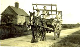
This picture must have been taken early in the twentieth century. It shows two ladies, a girl and a boy in charge of a hay cart and shire horse. It is by Meadow Farm along the Buckland Road. The style of cart is that of an Oxford cart.
Suzanne White says "This is a photograph that I have recently found of my great grandfather as a boy, Edward William Portlock (Clarke) - born in 1893 with his sisters Elsie and Eva Portlock outside a cottage where they lived at the time, along the Buckland Road as seen on the 1901 and 1911 census (I found the cottages on google and although now extended can clearly see they are still there). I think the picture would have been taken somewhere around 1906/8. I think the lady with them could be their mother who was called Elizabeth and I think her maiden name could have been Radband-Shepard but if that is the case I can’t find out too much about her."
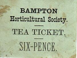
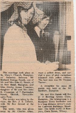
This ticket for a tea was found in a pile of bits and pieces when clearing out a garage. Teas were sold to raise funds for the Bampton Horticultural Society. The cost was 6 pence in old money - 6d - so pre decimalisation of February 1971.
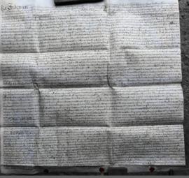
This Indenture on Vellum records :-A Release from William Thomas and Hester his Wife of Lands in Bampton Oxfordshire to Francis Sims Dated the Thirteenth day of June 1735.
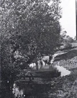
This peaceful scene is of an Ayrshire cow enjoying standing in the stream behind The Grange. It must have been taken fairly early in the twentieth century; by 1945 these cows were not often seen where they had once been bred