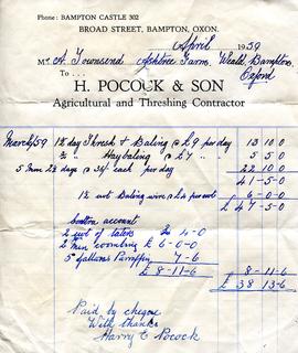
Invoice from Harry Pocock & Son, 1959
- BCA - 2022.3454
- Item
- 1959
Invoice from Harry Pocock & Son, 1959
Nik Stanbridge
203 results with digital objects Show results with digital objects
Invoice from Harry Pocock & Son, 1959
Invoice from Harry Pocock & Son, 1959
Nik Stanbridge
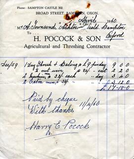
Invoice from Harry Pocock & Son, 19560
Invoice from Harry Pocock & Son, 19560
Nik Stanbridge
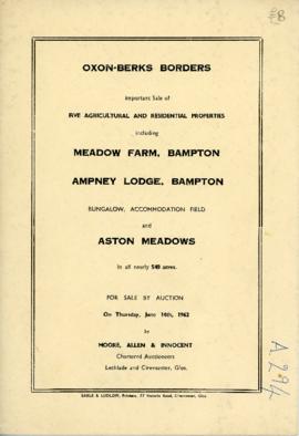
Sale brochure: Meadow farm; Ampney Lodge; Bungalow; Pasture field; Aston Meadows. June 14th 1962
Sale brochure: Meadow farm; Ampney Lodge; Bungalow; Pasture field; Aston Meadows. June 14th 1962
Nik Stanbridge

Map with the sale of 5 residential and agricultural properties 1962
This map was produce by Morre, Allan and Innocent to accompany the sale for 5 residential and agricultural properties May 14th 1962. They are all east and south east of Bampton's main residential area.
Lot 1 is Meadow Farm
Lot 2 is to the north of the Aston road and include Ampney Lodge
Lot 3 is a strip with Calais farm
Lot 4 is a field approximately where Bampton Garden Centre is today
Love 5 is a group of fields to the south of the Great Brook
Bampton Community Archive
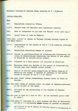
Documents relating to Bampton Among Archives of D&C in Exeter, compiles by Lloyd Hughes Owens
These are a collection of records compiled by Lloyd Hughes Owens and cover many aspects of local life and people. 1247 local tithes; 1275 extract from Quo Warranto Roll concerning tenures; 1288 Bond of obligation to pay rent for Vicars' house; 1262 Grant of land in Chimney; 1307-8 Confirmation of the rights of the D & C to manorial privilege in Bampton; 1318 Composition concerning common pasture; 1308-19 Records in suit - depositions of witnesses etc - concerning the tithes of Standlake and concerning the burial of the people of Standlake in Bampton parish church; 1360 Judgement in a suit against the chaplain of Standlake; 1406 Memoranda about the burials of the people of Standlake and Herdwyck away from Bampton parish church; 1445 Copy of an earlier grant, exemplified by Edmund Lacy, bishop of Exeter by the Bishop of Lincoln of portions of the parish church of Bampton to the D & C of Exeter; mid 15th century Draft letter recommending Richard Daber as Vicar of Bampton; late 15th century Group of letters about the manor of Bampton, addressed to the bailiff of the manor; 1503-4 Reference to the rebuilding of the chancel of Bampton church; Repairs made in 1496 at a cost of £20 in the accounts spread over 20 years; late 15th century? Reference to a suit between the Earl of Shrewsbury and the D & C concerning common of pasture in Bampton; 1670 Certificate by Bishop of Oxford re William Hodge's resignation of the vicarage; 1691 Receipt by Mr Veysey for the court rolls of Bampton. There is much more information in this collection of papers.
Bampton Community Archive
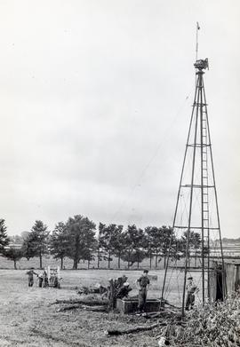
1965 A pylon that once held a windmill on White Owl Farm
This pylon was the framework that once held a windmill on White Owl farm. The farm belonged to Bert and Ted Wilkins.
Bampton Community Archive
Report on the Survey & Plan of Bampton by M W Robinson, County Planning Officer October 1966
This report on the Survey & Plan of Bampton was done under the guidance of M W Robinson FRICS MTPI in October 1966. It makes very interesting reading and the conclusions are as relevant today as they were then. The topics covered are 1. Population 2. Situation 3. Character 4. The people 5. Shopping 6. Principal road connections 7. Schools 8. Open spaces 9. Social facilities, Public Services etc 10. Surface water drainage 11. Sewage disposal 12. Water supply and much more. It makes a very interesting read particularly in the light of all the dwellings that have been built here since October 1966, all those being built now (Jan 2017) and those being proposed when considering the access into Bampton has not been improved yet in 1966 one of the conclusions states was that Bampton could not take further development, a by-pass was not possible and no further space for parking other than possibly in Church Street could be made. Houses have since been built on the land in Church Street
Nik Stanbridge
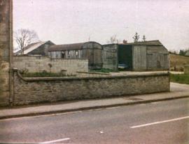
Castle View farm and house c1971
Castle View farm and house c1971
Nik Stanbridge

Ordnance Survey Plan SP3002-3102 1971. Cowleaze Corner Weald to Aston Road
Ordnance Survey Plan SP3002-3102 dated 1971. Cowleaze Corner, Weald to Aston, north to Horse Shoe
and showing the following places and buildings
Ashtree
Aulnoy
Backhouse Farm
Bournemead
Brook Farm
Brook House
Buckland Road
Caravan Park
Cheyne Lane
Clanfield Road
College Farm House
Corner Farm
Cowleaze Corner
Cricket Field
Dunlaoghaire
Fisher's Bridge
Gate Cottage
Glebe Cottage
Glebe Farm
Ham Court
Ham Court Cottages
Highmoor House
Knapps Farm
Lime Tree Cottages
Mill Bridge
Mill Green
Orchard Cottage
Primrose Cottages
Rose Cottage
Shill Brook
Shrangi-la
Spring Cottages
St Frideswide
Stable Cottage
Sunny view
Sunnyside
Thatch Cottage
The Bungalow
The Lodge
The Old Farmhouse
Weald Farm
Weald Farm Cottages
Weald Manor
Weald Manor Cottage
Weald Manor Farm
Janet Westman

These four maps were all produce in 1971 and cover
Ordinance Survey Plan SP3002-3102 Weald, Hayway Lane, Weald St, Clanfield Road
Ordinance Survey Plan SP3003-3103. Bridge St east to end of houses, north to new school, Colvile Close
Ordinance Survey Plan SP3203-3303. 1971 Mt Owen Rd east inc. Gogg Lane, Aston Rod to Aston
Ordinance Survey Plan SP3002-3102 1971. Cowleaze Corner, Weald to Aston, north to Horse Shoe PH
Fields, property and farms are all clearly marked.
Bampton Community Archive