These are two parts of one map created in 1914. I've picked them out to show where the school used to be in Lew, next to University Farm and the Post Office a little to the east just before you get to Trinity Church.
This map was produce for the sale of the Lew Estate in 1914. There used to be a Post Office and a school in Lew, both shown on this map between University Farm and Holy Trinity Church on the main road.
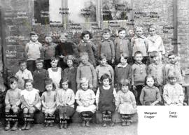
This is a class photograph taken about 1930. Vera Elward was then Vera Tanner and she is the blond girl centre front. The remaining 27 pictures are of each child with their name underneath
This report on the Survey & Plan of Bampton was done under the guidance of M W Robinson FRICS MTPI in October 1966. It makes very interesting reading and the conclusions are as relevant today as they were then. The topics covered are 1. Population 2. Situation 3. Character 4. The people 5. Shopping 6. Principal road connections 7. Schools 8. Open spaces 9. Social facilities, Public Services etc 10. Surface water drainage 11. Sewage disposal 12. Water supply and much more. It makes a very interesting read particularly in the light of all the dwellings that have been built here since October 1966, all those being built now (Jan 2017) and those being proposed when considering the access into Bampton has not been improved yet in 1966 one of the conclusions states was that Bampton could not take further development, a by-pass was not possible and no further space for parking other than possibly in Church Street could be made. Houses have since been built on the land in Church Street
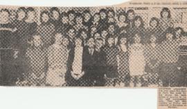
These three cuttings are all about a trip from Bampton school to Paris with 39 children. John Coombes (incorrect spelling under the photo in the cutting) was one of the school staff who went with the children.
In 1989 Mr Geoffrey Fowler, then the County Councillor for Bampton Division of Oxford, began the process of trying to get the National School in Church View listed as a "building of architectural and historic interest.