- BCA - 2020.2412
- Item
- November 2004
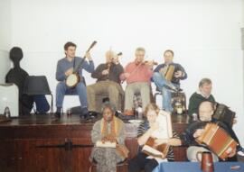
These pictures, all taken by Bob West record the November Morris party of Tony Daniels' side, held in the Village Hall.
Bampton Community Archive
1579 results with digital objects Show results with digital objects
These pictures, all taken by Bob West record the November Morris party of Tony Daniels' side, held in the Village Hall.
Bampton Community Archive
Spring Bank Holiday Morris Dancing 2005
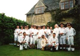
These photographs, all taken by Bob West record the Spring Bank Holiday Morris Dancing of Tony Daniels' side in 2005. Leyland Morris were the invited visiting dancers.
Bampton Community Archive
Francis Shergold & others May Bank Holiday weekend 1999
These pictures all taken by Bob West during the May Bank Holiday weekend in 1999. People in them include
Francis Shergold
Paul Goss
Rod Stradling
Bob Davenport
Bob West
Martin Landray
Ruth Wheeler
Ann Shergold
Danny Stradling
Reg Hall
Bampton Community Archive

This map was produce for the sale of the Lew Estate in 1914.
There used to be a Post Office and a school in Lew, both shown on this map between University Farm and Holy Trinity Church on the main road.
Bampton Community Archive

Map with sale of Lower Haddon Farm March 1949
Lower Haddon Farm in the very north of the Bampton area was sold in March 1949. One of these maps was produced by Jackson-Stops of Cirencester the auctioneers and the other was a hand drawn one. They show the names of the fields and what was being grown in them at the time.
Bampton Community Archive

Lew School and Post Office & Post Office Farm on a 1914 map
These are two parts of one map created in 1914. I've picked them out to show where the school used to be in Lew, next to University Farm and the Post Office a little to the east just before you get to Trinity Church.
Bampton Community Archive

This map shows the Bampton Estates at 1789. This is before the fields were enclosed and the names of the people who farmed the strips or the name of the field area are on the map. The Quies fields are each side of the Bampton to Brize Norton road, just north of what is now Hobbs Buildings.
The Clanfield to Bampton road is showing top to bottom on the map whereas it really runs east west, so you need to get your head around that, literally.
What we now call Welcome Way is called Wiltham Way - it runs south from Cowleaze Corner into Weald.
Weald Common Meadow was south of what we now think of as the area containing the two Bampton Business Parks.
The Bampton to Buckland road is showing going left to right on the map when it actually runs NW to SE; it had a turnpike.
Bampton Community Archive

1974 OS map of Bampton and Aston
This Ordinance Survey map was produced in 1974 and covers the area from Hobbs buildings/Deanery Farm in the north, due east to Coal Pit Farm, south to Bampton centre, on south to Weald, east to Aston and south to the Radcot Cut and Great Brook and the Thames.
Bampton Community Archive

These four maps were all produce in 1971 and cover
Ordinance Survey Plan SP3002-3102 Weald, Hayway Lane, Weald St, Clanfield Road
Ordinance Survey Plan SP3003-3103. Bridge St east to end of houses, north to new school, Colvile Close
Ordinance Survey Plan SP3203-3303. 1971 Mt Owen Rd east inc. Gogg Lane, Aston Rod to Aston
Ordinance Survey Plan SP3002-3102 1971. Cowleaze Corner, Weald to Aston, north to Horse Shoe PH
Fields, property and farms are all clearly marked.
Bampton Community Archive

Map with the sale of 5 residential and agricultural properties 1962
This map was produce by Morre, Allan and Innocent to accompany the sale for 5 residential and agricultural properties May 14th 1962. They are all east and south east of Bampton's main residential area.
Lot 1 is Meadow Farm
Lot 2 is to the north of the Aston road and include Ampney Lodge
Lot 3 is a strip with Calais farm
Lot 4 is a field approximately where Bampton Garden Centre is today
Love 5 is a group of fields to the south of the Great Brook
Bampton Community Archive