Ordnance Survey Plan SP3203-3303. 1971 Extending from Mt Owen Rd east inc. Gogg Lane, Aston Road and part of Aston. showing the following places: New Road White Owl Farm Bradshaw Close Kenlincott Kiln Close Back Lane Greenacres Lane Elmside Barry House Ferndale Back Cottage
Byeways Laundry Lane Kingsway Farm High Street West End The Limes West End Farm Home Farm House Greens Row Elvina Aston Ditch Mercury Close Beam Cottage Old Gasworks Building New Road The Willows St Andrews
Ordnance Survey Plan SP3002-3102 dated 1971. Cowleaze Corner, Weald to Aston, north to Horse Shoe and showing the following places and buildings Ashtree Aulnoy Backhouse Farm Bournemead Brook Farm Brook House Buckland Road Caravan Park Cheyne Lane Clanfield Road College Farm House Corner Farm Cowleaze Corner Cricket Field Dunlaoghaire Fisher's Bridge Gate Cottage Glebe Cottage Glebe Farm Ham Court Ham Court Cottages Highmoor House Knapps Farm Lime Tree Cottages Mill Bridge Mill Green Orchard Cottage Primrose Cottages Rose Cottage Shill Brook Shrangi-la Spring Cottages St Frideswide Stable Cottage Sunny view Sunnyside Thatch Cottage The Bungalow The Lodge The Old Farmhouse Weald Farm Weald Farm Cottages Weald Manor Weald Manor Cottage Weald Manor Farm
These four maps were all produce in 1971 and cover
Ordinance Survey Plan SP3002-3102 Weald, Hayway Lane, Weald St, Clanfield Road Ordinance Survey Plan SP3003-3103. Bridge St east to end of houses, north to new school, Colvile Close Ordinance Survey Plan SP3203-3303. 1971 Mt Owen Rd east inc. Gogg Lane, Aston Rod to Aston Ordinance Survey Plan SP3002-3102 1971. Cowleaze Corner, Weald to Aston, north to Horse Shoe PH
Fields, property and farms are all clearly marked.
This Ordinance Survey map was produced in 1974 and covers the area from Hobbs buildings/Deanery Farm in the north, due east to Coal Pit Farm, south to Bampton centre, on south to Weald, east to Aston and south to the Radcot Cut and Great Brook and the Thames.
Huge thanks to Janet Westman for allowing us to put her maps on this website for all to see for free when they are still available for sale, either as black and white or hand coloured by Janet. The Witney map you can see her in black and white and coloured.
The maps are of Brize Norton Cassington Eynsham Gloucestershire Oxfordshire Witney
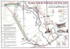
Map of circular walk around Bampton which goes through Plantation and around Ham Court to Clanfield Road names old fields and meadows i.e. Ham Field, Long Hedge Furlong, Turf Close, Shill Brook, Peeks Ham Close, Norloin's Furlon, High Moor Meadow, Hilly Leaze