Showing 27 results
Archival description
Maps of East Half of Bampton 1921

1797 Map showing Bampton Hundred

Ordnance Survey PlanSP3002-3102 Weald, Hayway Lane, Weald St, Clanfield Rd. 1971

Ordnance Survey Map dated 1922 Grafton to Chimney including villages
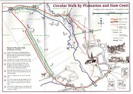
Circular Walk Map - Plantation and Ham Court

Bampton maps of 1921

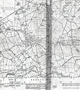
1974 OS map of Bampton and Aston
Public Footpaths in Bampton

Pre Inclosure map of Clanfield, Bampton, Aston & Yelford

Map of Weald from Plantation south to Cowleaze Corner, east to the Elephant & Castle
Results 1 to 10 of 27