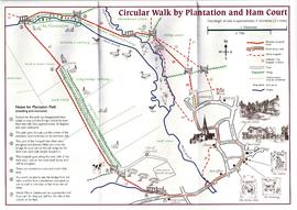
Map of circular walk around Bampton which goes through Plantation and around Ham Court to Clanfield Road names old fields and meadows i.e. Ham Field, Long Hedge Furlong, Turf Close, Shill Brook, Peeks Ham Close, Norloin's Furlon, High Moor Meadow, Hilly Leaze
Huge thanks to Janet Westman for allowing us to put her maps on this website for all to see for free when they are still available for sale, either as black and white or hand coloured by Janet. The Witney map you can see her in black and white and coloured.
The maps are of Brize Norton Cassington Eynsham Gloucestershire Oxfordshire Witney
This Ordinance Survey map was produced in 1974 and covers the area from Hobbs buildings/Deanery Farm in the north, due east to Coal Pit Farm, south to Bampton centre, on south to Weald, east to Aston and south to the Radcot Cut and Great Brook and the Thames.
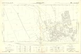
This Ordnance Survey Plan SP3003-3103. Dated 1971 shows area Bridge St east to end of houses, north to new school, Colvile Close etc Properties and Streets listed : Air Training Corps Ampney Lodge Apple Tree Cottage April Cottage Army cadet Hut Bakery Bampton House Bay Tree Cottage Belgrave Cottage Blackthorn Cottage Blackthorn Cottagre Bourton Cottage Box House Bushey House Calais Farm Cheapside Chestnuts Churchgate House Churchgate House Clevelly Cobb House Corner Cottage Cornmill Cotsway Cotswold Lodge Courtlands Dairy Farm House Deanery Farm Down Home Elephant and Castle Eton Villas Felix Cottage Fernlea Field Cottage Fishers Bridge Fleur de Lys Folly House Folly View Fox Close George and Dragon Grayshot House Ham Court Haytor House Highmoor Brook Inglenook Cottage Kilmore House Kilmore House Landells Leighton Cottage Lester House Library Lime Tree House Little Pinkneys Little Place Cottage Littlemead Lynton Mead Mallows Manor House Matthew House Melita Moss Rose Cottage Oathurst Estate Plantation Pococks Close Police Office Poplar Cottage Primrose Cottages Priory Cottage Prospect Cottage Prospect House Prospect Place Quebec Cottage Rhandom Roseann Rosebrook Rosemary House San Toy Sandford House Southrop House Southside St Johns House St Oswald Sunnyside Cottage Thatched Cottage The Bungalow The Deanery The Eagle The Elms The Gate Cottage The Glen The Grange The Grey House The Haven The Hermitage The Horse Shoe The Jubilee The Malt Shovel The Old Forge The Vicarage The Yews Town Hall Tudor Cottage Turnings Vaizey Cottage Vicarage Victoria Cottages Vine Cottage Weald Manor House Wheelgate House Windsmore Windsor Cottagres Yew Tree Cottage Youth Club Ampney Orchard Aston Road Bowling Green Close Bridge Street Broad Street Buckland Road Bushey Row Chandler Close Cheapside Church Lane Church Street Church View Colvile Close Glebelands High Street High Street Lavender Square Manor View Mercury Close New Road Queens Street Rosemary Lane
Ordnance Survey Plan SP3203-3303. 1971 Extending from Mt Owen Rd east inc. Gogg Lane, Aston Road and part of Aston. showing the following places: New Road White Owl Farm Bradshaw Close Kenlincott Kiln Close Back Lane Greenacres Lane Elmside Barry House Ferndale Back Cottage
Byeways Laundry Lane Kingsway Farm High Street West End The Limes West End Farm Home Farm House Greens Row Elvina Aston Ditch Mercury Close Beam Cottage Old Gasworks Building New Road The Willows St Andrews
Ordnance Survey Plan SP3002-3102 dated 1971. Cowleaze Corner, Weald to Aston, north to Horse Shoe and showing the following places and buildings Ashtree Aulnoy Backhouse Farm Bournemead Brook Farm Brook House Buckland Road Caravan Park Cheyne Lane Clanfield Road College Farm House Corner Farm Cowleaze Corner Cricket Field Dunlaoghaire Fisher's Bridge Gate Cottage Glebe Cottage Glebe Farm Ham Court Ham Court Cottages Highmoor House Knapps Farm Lime Tree Cottages Mill Bridge Mill Green Orchard Cottage Primrose Cottages Rose Cottage Shill Brook Shrangi-la Spring Cottages St Frideswide Stable Cottage Sunny view Sunnyside Thatch Cottage The Bungalow The Lodge The Old Farmhouse Weald Farm Weald Farm Cottages Weald Manor Weald Manor Cottage Weald Manor Farm
These four maps were all produce in 1971 and cover
Ordinance Survey Plan SP3002-3102 Weald, Hayway Lane, Weald St, Clanfield Road Ordinance Survey Plan SP3003-3103. Bridge St east to end of houses, north to new school, Colvile Close Ordinance Survey Plan SP3203-3303. 1971 Mt Owen Rd east inc. Gogg Lane, Aston Rod to Aston Ordinance Survey Plan SP3002-3102 1971. Cowleaze Corner, Weald to Aston, north to Horse Shoe PH
Fields, property and farms are all clearly marked.
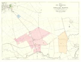
Plan of south Bampton showing 5 lots for sale. issued by Moore Allen and Innocent on June 14th 1962. Lot 2 is where Ampney Orchard is now. Also shown Isle of Wight Bridge, Tadpole, The Trout, Great Book, River Thames, Cote House. Chimney, Meadow Farm, Meadow Arch Bridge, Old gravel pit, Calais Farm,
This map was produce by Morre, Allan and Innocent to accompany the sale for 5 residential and agricultural properties May 14th 1962. They are all east and south east of Bampton's main residential area. Lot 1 is Meadow Farm Lot 2 is to the north of the Aston road and include Ampney Lodge Lot 3 is a strip with Calais farm Lot 4 is a field approximately where Bampton Garden Centre is today Love 5 is a group of fields to the south of the Great Brook