Showing 23 results
Archival description23 results with digital objects Show results with digital objects

Map of Weald from Plantation south to Cowleaze Corner, east to the Elephant & Castle

Map of Bampton Estate at 1789

Map of 1797. Westwell east to Curbridge, Kemscott east to Coat Common plus St Giles Oxford

Map 1913 Edition Marsh Lane East incl Weald and Clanfield Road

Lew School and Post Office & Post Office Farm on a 1914 map

Four OS maps of Bampton 1971
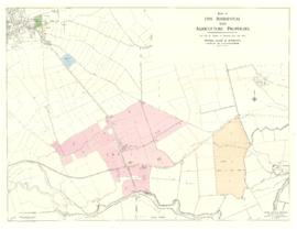
Five Residential and Agricultural Plots for Sale 1962

Bampton maps of 1921

Bampton at Time of the Enclosure Act 1821

2nd edition maps of 1899 Bampton, Black Bourton, Mt Owen Road
Results 11 to 20 of 23
- « Previous
- 1
- 2
- 3
- Next »