Showing 26 results

Archival description
Only top-level descriptions Maps With digital objects
Print preview View:

Five Residential and Agricultural Plots for Sale 1962

  • BCA - 2022.3815
  • Item
  • 1962

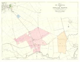
Plan of south Bampton showing 5 lots for sale. issued by Moore Allen and Innocent on June 14th 1962.
Lot 2 is where Ampney Orchard is now.
Also shown Isle of Wight Bridge, Tadpole, The Trout, Great Book, River Thames, Cote House. Chimney, Meadow Farm, Meadow Arch Bridge, Old gravel pit, Calais Farm,

Janet Westman

Maps of East Half of Bampton 1921

  • BCA - 2022.3814
  • Item
  • 1921

3 Large ordnance Survey Maps used by Hadgood and Mammatt Auctioneers and Estate Agents from Witney. Published in 1921 price £5/- and £6/8d. Points of interest are Highmoor Brook, Plantation, Ham Court, Deanery Farm, Churchgate, Vicarage, Manor House, and Weald Manor House, old gravel pit and Beam Cottage, Calais Farm, Primrose Cottages, Fisher's Bridge

Janet Westman

Map 1913 Edition Marsh Lane East incl Weald and Clanfield Road

  • BCA - 2022.3812
  • Item
  • 1913

Ordnance Survey Map showing Area from Marsh Lane, Weald and Clanfield Road,
used by Habgood and Mammatt Chartered Auctioneers and Estate Agents of Witney
Some Pencil markings showing land belonging to Parker, Abingdon Poor, Litchfield, Buckingham, Townsend, and "Little Weald" Auction 15/6/62.
Printed and published by Ordnance Survey Office Southampton 1913 Price 3/-

Janet Westman

The Lew Estate 1914

  • BCA - 2020.2396
  • Item
  • 1914

This map was produce for the sale of the Lew Estate in 1914.
There used to be a Post Office and a school in Lew, both shown on this map between University Farm and Holy Trinity Church on the main road.

Bampton Community Archive

Map with sale of Lower Haddon Farm March 1949

  • BCA - 2020.2404
  • Item
  • March 1949

Lower Haddon Farm in the very north of the Bampton area was sold in March 1949. One of these maps was produced by Jackson-Stops of Cirencester the auctioneers and the other was a hand drawn one. They show the names of the fields and what was being grown in them at the time.

Bampton Community Archive

Lew School and Post Office & Post Office Farm on a 1914 map

  • BCA - 2020.2403
  • Item
  • 1914

These are two parts of one map created in 1914. I've picked them out to show where the school used to be in Lew, next to University Farm and the Post Office a little to the east just before you get to Trinity Church.

Bampton Community Archive

Map of Bampton Estate at 1789

  • BCA - 2019.1890
  • Item
  • 1789

This map shows the Bampton Estates at 1789. This is before the fields were enclosed and the names of the people who farmed the strips or the name of the field area are on the map. The Quies fields are each side of the Bampton to Brize Norton road, just north of what is now Hobbs Buildings.
The Clanfield to Bampton road is showing top to bottom on the map whereas it really runs east west, so you need to get your head around that, literally.
What we now call Welcome Way is called Wiltham Way - it runs south from Cowleaze Corner into Weald.
Weald Common Meadow was south of what we now think of as the area containing the two Bampton Business Parks.
The Bampton to Buckland road is showing going left to right on the map when it actually runs NW to SE; it had a turnpike.

Bampton Community Archive

1974 OS map of Bampton and Aston

  • BCA - 2020.2402
  • Item
  • 1974

This Ordinance Survey map was produced in 1974 and covers the area from Hobbs buildings/Deanery Farm in the north, due east to Coal Pit Farm, south to Bampton centre, on south to Weald, east to Aston and south to the Radcot Cut and Great Brook and the Thames.

Bampton Community Archive

Four OS maps of Bampton 1971

  • BCA - 2020.2401
  • Item
  • 1971

These four maps were all produce in 1971 and cover

Ordinance Survey Plan SP3002-3102 Weald, Hayway Lane, Weald St, Clanfield Road
Ordinance Survey Plan SP3003-3103. Bridge St east to end of houses, north to new school, Colvile Close
Ordinance Survey Plan SP3203-3303. 1971 Mt Owen Rd east inc. Gogg Lane, Aston Rod to Aston
Ordinance Survey Plan SP3002-3102 1971. Cowleaze Corner, Weald to Aston, north to Horse Shoe PH

Fields, property and farms are all clearly marked.

Bampton Community Archive

Map with the sale of 5 residential and agricultural properties 1962

  • BCA - 2020.2400
  • Item
  • June 14th 1962

This map was produce by Morre, Allan and Innocent to accompany the sale for 5 residential and agricultural properties May 14th 1962. They are all east and south east of Bampton's main residential area.
Lot 1 is Meadow Farm
Lot 2 is to the north of the Aston road and include Ampney Lodge
Lot 3 is a strip with Calais farm
Lot 4 is a field approximately where Bampton Garden Centre is today
Love 5 is a group of fields to the south of the Great Brook

Bampton Community Archive

Results 11 to 20 of 26