Agriculture and Farming

Taxonomy

Code

Scope note(s)

Source note(s)

Display note(s)

Hierarchical terms

Agriculture and Farming

Equivalent terms

Agriculture and Farming

Associated terms

Agriculture and Farming

207 Archival description results for Agriculture and Farming

207 results directly related Exclude narrower terms

Four OS maps of Bampton 1971

  • BCA - 2020.2401
  • Item
  • 1971

These four maps were all produce in 1971 and cover

Ordinance Survey Plan SP3002-3102 Weald, Hayway Lane, Weald St, Clanfield Road
Ordinance Survey Plan SP3003-3103. Bridge St east to end of houses, north to new school, Colvile Close
Ordinance Survey Plan SP3203-3303. 1971 Mt Owen Rd east inc. Gogg Lane, Aston Rod to Aston
Ordinance Survey Plan SP3002-3102 1971. Cowleaze Corner, Weald to Aston, north to Horse Shoe PH

Fields, property and farms are all clearly marked.

Bampton Community Archive

1974 OS map of Bampton and Aston

  • BCA - 2020.2402
  • Item
  • 1974

This Ordinance Survey map was produced in 1974 and covers the area from Hobbs buildings/Deanery Farm in the north, due east to Coal Pit Farm, south to Bampton centre, on south to Weald, east to Aston and south to the Radcot Cut and Great Brook and the Thames.

Bampton Community Archive

Map of Bampton Estate at 1789

  • BCA - 2019.1890
  • Item
  • 1789

This map shows the Bampton Estates at 1789. This is before the fields were enclosed and the names of the people who farmed the strips or the name of the field area are on the map. The Quies fields are each side of the Bampton to Brize Norton road, just north of what is now Hobbs Buildings.
The Clanfield to Bampton road is showing top to bottom on the map whereas it really runs east west, so you need to get your head around that, literally.
What we now call Welcome Way is called Wiltham Way - it runs south from Cowleaze Corner into Weald.
Weald Common Meadow was south of what we now think of as the area containing the two Bampton Business Parks.
The Bampton to Buckland road is showing going left to right on the map when it actually runs NW to SE; it had a turnpike.

Bampton Community Archive

Lew School and Post Office & Post Office Farm on a 1914 map

  • BCA - 2020.2403
  • Item
  • 1914

These are two parts of one map created in 1914. I've picked them out to show where the school used to be in Lew, next to University Farm and the Post Office a little to the east just before you get to Trinity Church.

Bampton Community Archive

Map with sale of Lower Haddon Farm March 1949

  • BCA - 2020.2404
  • Item
  • March 1949

Lower Haddon Farm in the very north of the Bampton area was sold in March 1949. One of these maps was produced by Jackson-Stops of Cirencester the auctioneers and the other was a hand drawn one. They show the names of the fields and what was being grown in them at the time.

Bampton Community Archive

The Lew Estate 1914

  • BCA - 2020.2396
  • Item
  • 1914

This map was produce for the sale of the Lew Estate in 1914.
There used to be a Post Office and a school in Lew, both shown on this map between University Farm and Holy Trinity Church on the main road.

Bampton Community Archive

1922 map of Clanfield, Alvescot, Black Bourton, Grafton, Bampton, Aston, Cote & Chimney

  • BCA - 2020.2399
  • Item
  • 1922

This map was produced in 1922 and shows the field system as well as the parliamentary boundaries as at 1918.

There are many interesting notes written on in pencil. The water tower and gas works along the Aston Road were in existence. The allotment gardens NW of Beam Cottage are labelled as is the gravel pit to the SW of Beam Cottage.

There are no houses to the north of New Road and none to the south of it going east from Bushey Row.

Rushy Weir is shown clearly as is the tow path to the south side of the river Thames.

Bampton Community Archive

Threshing machine

  • BCA - 2020.2362
  • Item
  • early twentieth century

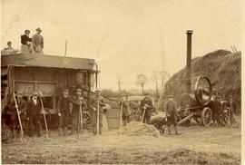
This threshing machine was used to thresh the grain from the stooks of corn and was the normal way to do this in the first half of the twentieth century, before the combine harvester did the job as the corn was cut in the field.

It was a labour intensive job with people taking stooks from the pile, others lobbed them on to the top where yet more people fed them into the machine. Two ladies and a man can be seen on top of the threshing machine doing this part of the job.

At least one person hooked sacks on to the back to catch the grain while others gathered up the straw and chaff. The straw would have been used for bedding animals under cover in winter and some used as feed.

The whole machine was belt driven - no protection - with power from a steam engine which had men keeping it going in good order. With a live fire in the steam engine, it's no wonder there were fires in the ricks from time to time.

There are 13 people working in this picture. Some have bailing string tied round their calves, probably to stop rats running up as the rick was slowly dismantled.

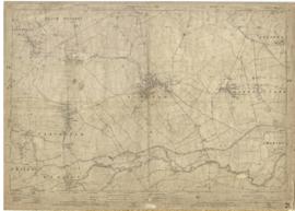
A threshing machine is nearly always seen working at the Fairford, Faringdon, Filkins & Burford ploughing match held the last Saturday in September on a farm within 16 miles of Lechlade.

Bampton Community Archive

Morris Men outside the Elephant & Castle c1924

  • BCA - 2020.2338
  • Item
  • 1924 or 1925

Bampton Morris dancers c1924/5 outside the Elephant & Castle.

The sign over the pub door says Posting House, Horses, Carriages, Brakes. Personal attention given, Albert Townsend. The 3rd and 4th lines are hard to read which is a pity but it looks like 'For Hire All Trains Met On The Shortest Notice.

On 23rd September 1935 the Townsend family moved across the road to Castle View and made a farm of it having much more room to fatten more pigs.

Bampton Community Archive

Improving access to Oxfordshire's countryside and green spaces

  • BCA - 2017.1138
  • Item
  • May 2017

TOE2 is Oxfordshire’s independent environmental funder, supporting projects that make real and lasting improvements to the environment and to the lives of local people. TOE2, a charity and a notfor-profit company, has worked in partnership with OCC for several years to improve access to rights of way and green spaces across the county, supporting the aims of the Oxfordshire Rights of Way Improvement Plan

Bampton Community Archive

Results 11 to 20 of 207